|
|
|||||||||||||||||
| Point ID: 5897 | Downloads | Plots | Site Data | Code: 1341 |
|
|
|||||||||||||||||
| Download | |
|---|---|
| Site Descriptor Information | Site Time Series Data |
| Link to all available data | |
| View: | Time Series | All |
| Units: | mm |
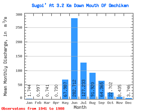
| Statistic | Jan | Feb | Mar | Apr | May | Jun | Jul | Aug | Sep | Oct | Nov | Dec | Annual |
|---|---|---|---|---|---|---|---|---|---|---|---|---|---|
| Mean | 1.74 | 1.00 | 0.74 | 0.73 | 67.99 | 282.71 | 127.23 | 91.92 | 64.36 | 22.70 | 8.44 | 3.75 | 56.59 |
| Standard Deviation | 0.90 | 0.50 | 0.43 | 0.42 | 50.38 | 110.10 | 54.62 | 41.81 | 34.40 | 9.14 | 3.00 | 1.77 | 13.67 |
| Min | 0.45 | 0.14 | 0.10 | 0.09 | 1.47 | 120.00 | 46.60 | 31.20 | 23.50 | 11.50 | 3.73 | 0.97 | 36.17 |
| Max | 4.52 | 2.85 | 2.80 | 2.26 | 259.00 | 640.00 | 317.00 | 241.00 | 170.00 | 53.40 | 15.90 | 8.93 | 91.45 |
| Coefficient of Variation | 0.52 | 0.50 | 0.57 | 0.58 | 0.74 | 0.39 | 0.43 | 0.46 | 0.53 | 0.40 | 0.36 | 0.47 | 0.24 |
 Return to R-Arctic Net Home Page