|
|
|||||||||||||||||
| Point ID: 5894 | Downloads | Plots | Site Data | Code: 1309 |
|
|
|||||||||||||||||
| Download | |
|---|---|
| Site Descriptor Information | Site Time Series Data |
| Link to all available data | |
| View: | Time Series | All |
| Units: | m3/s |
| Statistic | Jan | Feb | Mar | Apr | May | Jun | Jul | Aug | Sep | Oct | Nov | Dec | Annual |
|---|---|---|---|---|---|---|---|---|---|---|---|---|---|
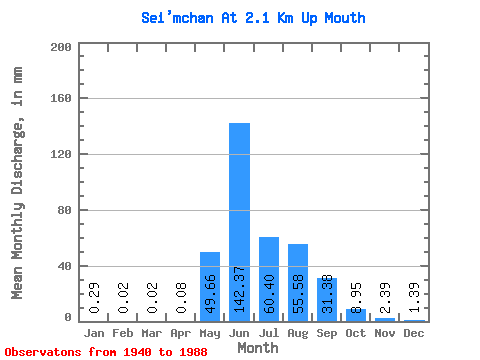
| Mean | 0.29 | 0.02 | 0.02 | 0.08 | 49.65 | 142.37 | 60.39 | 55.57 | 31.38 | 8.95 | 2.38 | 1.39 | 380.86 |
| Standard Deviation | 0.20 | 0.03 | 0.10 | 39.31 | 66.13 | 30.01 | 26.53 | 14.54 | 4.55 | 1.14 | 5.11 | ||
| Min | 0.01 | 0.00 | 0.02 | 0.00 | 1.02 | 57.08 | 21.46 | 21.64 | 8.96 | 1.34 | 0.01 | 0.04 | 380.86 |
| Max | 0.70 | 0.07 | 0.02 | 0.24 | 167.83 | 300.92 | 139.40 | 123.81 | 76.07 | 29.35 | 6.21 | 31.00 | 380.86 |
| Coefficient of Variation | 0.70 | 1.44 | 1.30 | 0.79 | 0.47 | 0.50 | 0.48 | 0.46 | 0.51 | 0.48 | 3.69 |
 Return to R-Arctic Net Home Page