|
|
|||||||||||||||||
| Point ID: 5894 | Downloads | Plots | Site Data | Code: 1309 |
|
|
|||||||||||||||||
| Download | |
|---|---|
| Site Descriptor Information | Site Time Series Data |
| Link to all available data | |
| View: | Time Series | All |
| Units: | mm |
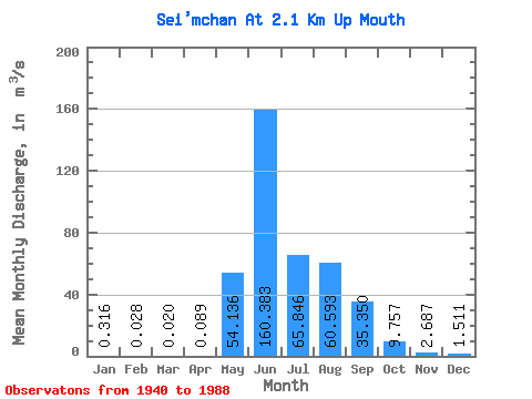
| Statistic | Jan | Feb | Mar | Apr | May | Jun | Jul | Aug | Sep | Oct | Nov | Dec | Annual |
|---|---|---|---|---|---|---|---|---|---|---|---|---|---|
| Mean | 0.32 | 0.03 | 0.02 | 0.09 | 54.14 | 160.38 | 65.85 | 60.59 | 35.35 | 9.76 | 2.69 | 1.51 | 35.24 |
| Standard Deviation | 0.22 | 0.04 | 0.12 | 42.86 | 74.50 | 32.73 | 28.93 | 16.38 | 4.96 | 1.28 | 5.57 | ||
| Min | 0.01 | 0.00 | 0.02 | 0.00 | 1.11 | 64.30 | 23.40 | 23.60 | 10.10 | 1.46 | 0.01 | 0.04 | 35.24 |
| Max | 0.76 | 0.09 | 0.02 | 0.27 | 183.00 | 339.00 | 152.00 | 135.00 | 85.70 | 32.00 | 6.99 | 33.80 | 35.24 |
| Coefficient of Variation | 0.70 | 1.44 | 1.30 | 0.79 | 0.47 | 0.50 | 0.48 | 0.46 | 0.51 | 0.48 | 3.69 |
 Return to R-Arctic Net Home Page