|
|
|||||||||||||||||
| Point ID: 5889 | Downloads | Plots | Site Data | Code: 1293 |
|
|
|||||||||||||||||
| Download | |
|---|---|
| Site Descriptor Information | Site Time Series Data |
| Link to all available data | |
| View: | Time Series | All |
| Units: | m3/s |
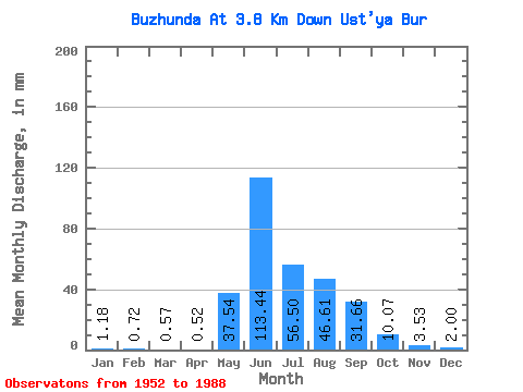
| Statistic | Jan | Feb | Mar | Apr | May | Jun | Jul | Aug | Sep | Oct | Nov | Dec | Annual |
|---|---|---|---|---|---|---|---|---|---|---|---|---|---|
| Mean | 1.18 | 0.72 | 0.57 | 0.52 | 37.53 | 113.44 | 56.50 | 46.60 | 31.66 | 10.07 | 3.53 | 2.00 | 295.42 |
| Standard Deviation | 0.62 | 0.38 | 0.34 | 0.29 | 27.13 | 54.62 | 28.70 | 21.77 | 19.36 | 4.71 | 1.62 | 1.12 | 76.07 |
| Min | 0.19 | 0.10 | 0.08 | 0.07 | 4.42 | 46.19 | 17.00 | 15.73 | 9.92 | 4.89 | 1.43 | 0.49 | 166.88 |
| Max | 2.70 | 1.41 | 1.57 | 1.25 | 130.22 | 293.70 | 162.33 | 100.17 | 100.37 | 26.25 | 8.50 | 5.36 | 460.51 |
| Coefficient of Variation | 0.53 | 0.52 | 0.59 | 0.55 | 0.72 | 0.48 | 0.51 | 0.47 | 0.61 | 0.47 | 0.46 | 0.56 | 0.26 |
 Return to R-Arctic Net Home Page