|
|
|||||||||||||||||
| Point ID: 5889 | Downloads | Plots | Site Data | Code: 1293 |
|
|
|||||||||||||||||
| Download | |
|---|---|
| Site Descriptor Information | Site Time Series Data |
| Link to all available data | |
|
|
| View: | Statistics | Time Series |
| Units: | m3/s |
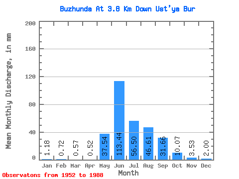
| Statistic | Jan | Feb | Mar | Apr | May | Jun | Jul | Aug | Sep | Oct | Nov | Dec | Annual |
|---|---|---|---|---|---|---|---|---|---|---|---|---|---|
| Mean | 1.18 | 0.72 | 0.57 | 0.52 | 37.53 | 113.44 | 56.50 | 46.60 | 31.66 | 10.07 | 3.53 | 2.00 | 295.42 |
| Standard Deviation | 0.62 | 0.38 | 0.34 | 0.29 | 27.13 | 54.62 | 28.70 | 21.77 | 19.36 | 4.71 | 1.62 | 1.12 | 76.07 |
| Min | 0.19 | 0.10 | 0.08 | 0.07 | 4.42 | 46.19 | 17.00 | 15.73 | 9.92 | 4.89 | 1.43 | 0.49 | 166.88 |
| Max | 2.70 | 1.41 | 1.57 | 1.25 | 130.22 | 293.70 | 162.33 | 100.17 | 100.37 | 26.25 | 8.50 | 5.36 | 460.51 |
| Coefficient of Variation | 0.53 | 0.52 | 0.59 | 0.55 | 0.72 | 0.48 | 0.51 | 0.47 | 0.61 | 0.47 | 0.46 | 0.56 | 0.26 |
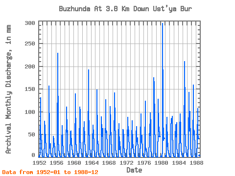
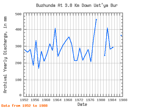
| Year | Jan | Feb | Mar | Apr | May | Jun | Jul | Aug | Sep | Oct | Nov | Dec | Annual | 1952 | 1.29 | 0.52 | 0.41 | 0.40 | 9.60 | 130.31 | 46.25 | 51.85 | 23.87 | 8.13 | 4.08 | 0.75 | 277.72 | 1953 | 0.32 | 0.14 | 0.08 | 0.38 | 37.41 | 79.27 | 64.81 | 39.77 | 23.55 | 14.02 | 3.73 | 1.84 | 264.09 | 1954 | 1.28 | 1.03 | 0.92 | 0.82 | 12.73 | 156.26 | 38.01 | 20.33 | 29.94 | 9.66 | 5.16 | 2.62 | 280.11 | 1955 | 0.82 | 0.34 | 0.17 | 0.21 | 41.24 | 46.19 | 38.59 | 25.01 | 21.67 | 7.13 | 3.11 | 1.76 | 185.26 | 1956 | 1.46 | 1.19 | 1.00 | 0.84 | 9.84 | 228.97 | 40.07 | 17.12 | 22.64 | 4.89 | 2.24 | 1.45 | 334.18 | 1957 | 0.85 | 0.52 | 0.41 | 0.26 | 27.61 | 69.58 | 29.20 | 20.15 | 9.92 | 5.45 | 2.02 | 1.20 | 166.88 | 1958 | 0.78 | 0.51 | 0.43 | 0.34 | 9.63 | 109.78 | 57.45 | 60.98 | 19.25 | 7.04 | 2.99 | 2.01 | 270.69 | 1959 | 1.18 | 0.81 | 0.63 | 0.59 | 57.74 | 57.31 | 25.72 | 30.34 | 24.27 | 8.43 | 2.74 | 1.64 | 210.46 | 1960 | 1.08 | 0.73 | 0.47 | 0.47 | 8.48 | 138.87 | 33.29 | 36.83 | 18.34 | 6.63 | 4.08 | 2.75 | 252.84 | 1961 | 2.01 | 1.26 | 0.77 | 0.34 | 17.59 | 110.35 | 102.52 | 40.66 | 25.64 | 10.19 | 3.02 | 1.34 | 314.69 | 1962 | 0.83 | 0.45 | 0.43 | 0.47 | 67.47 | 60.45 | 81.02 | 36.83 | 18.54 | 7.48 | 2.99 | 1.35 | 276.06 | 1963 | 1.10 | 1.01 | 0.82 | 0.62 | 9.66 | 192.19 | 88.97 | 76.89 | 21.98 | 9.60 | 3.65 | 1.38 | 407.80 | 1964 | 0.53 | 0.35 | 0.37 | 0.29 | 32.41 | 70.72 | 43.60 | 61.57 | 21.07 | 6.19 | 2.55 | 1.33 | 239.79 | 1965 | 0.69 | 0.52 | 0.46 | 0.45 | 20.24 | 147.42 | 38.01 | 35.06 | 22.95 | 7.45 | 3.02 | 1.80 | 278.79 | 1966 | 0.75 | 0.43 | 0.34 | 0.33 | 30.05 | 88.97 | 57.45 | 46.84 | 63.30 | 12.31 | 4.91 | 4.07 | 309.38 | 1967 | 2.07 | 1.03 | 0.86 | 0.72 | 130.22 | 54.46 | 60.10 | 56.56 | 23.98 | 6.72 | 1.48 | 0.84 | 335.70 | 1968 | 0.57 | 0.33 | 0.47 | 0.92 | 98.69 | 111.78 | 76.89 | 35.94 | 19.90 | 9.07 | 3.05 | 0.65 | 356.30 | 1969 | 0.31 | 0.22 | 0.15 | 0.11 | 19.71 | 141.15 | 78.37 | 41.24 | 19.45 | 10.08 | 2.00 | 1.09 | 313.57 | 1970 | 0.71 | 0.34 | 0.20 | 0.12 | 50.08 | 73.85 | 17.00 | 17.71 | 34.22 | 12.90 | 4.50 | 2.75 | 214.25 | 1971 | 1.82 | 1.05 | 0.59 | 0.47 | 62.46 | 59.03 | 43.31 | 24.57 | 13.03 | 5.54 | 1.58 | 1.49 | 213.60 | 1972 | 0.80 | 0.51 | 0.28 | 0.17 | 34.17 | 87.54 | 48.61 | 48.61 | 59.31 | 7.10 | 2.30 | 1.40 | 290.52 | 1973 | 0.65 | 0.40 | 0.22 | 0.12 | 39.77 | 80.13 | 22.12 | 32.41 | 23.24 | 10.46 | 3.45 | 3.09 | 215.72 | 1974 | 1.73 | 0.75 | 0.49 | 0.58 | 49.20 | 67.58 | 35.06 | 35.35 | 42.20 | 13.38 | 3.14 | 1.93 | 250.67 | 1975 | 0.93 | 0.35 | 0.35 | 0.46 | 38.59 | 95.53 | 45.96 | 33.88 | 48.19 | 10.37 | 3.31 | 2.63 | 280.35 | 1976 | 1.63 | 0.81 | 0.50 | 0.39 | 10.72 | 122.61 | 25.16 | 15.73 | 17.79 | 6.36 | 2.99 | 1.67 | 207.43 | 1977 | 0.88 | 0.36 | 0.18 | 0.16 | 43.90 | 63.30 | 49.20 | 100.17 | 67.30 | 23.30 | 1.51 | 0.49 | 348.80 | 1978 | 0.19 | 0.10 | 0.08 | 0.07 | 14.29 | 174.80 | 162.33 | 78.95 | 21.70 | 7.34 | 1.43 | 1.07 | 460.51 | 1979 | 0.84 | 0.69 | 0.81 | 0.92 | 69.53 | 127.75 | 67.47 | 68.64 | 45.91 | 1980 | 1.24 | 1.06 | 1.03 | 14.26 | 293.70 | 94.28 | 38.30 | 41.06 | 1981 | 2.26 | 1.26 | 0.88 | 0.84 | 57.74 | 87.83 | 24.36 | 32.11 | 18.16 | 11.61 | 5.76 | 3.09 | 245.30 | 1982 | 2.00 | 1.25 | 0.90 | 0.77 | 65.11 | 84.40 | 84.55 | 93.10 | 63.59 | 11.34 | 3.42 | 1.91 | 410.05 | 1983 | 1.41 | 1.09 | 1.07 | 0.75 | 43.31 | 71.57 | 46.25 | 78.07 | 22.81 | 10.58 | 4.85 | 2.07 | 282.10 | 1984 | 1.17 | 0.65 | 0.41 | 0.60 | 61.57 | 94.95 | 60.40 | 46.25 | 17.02 | 7.10 | 2.48 | 2.24 | 293.37 | 1985 | 1.42 | 1.00 | 0.65 | 0.57 | 17.73 | 209.87 | 98.99 | 66.29 | 35.07 | 11.31 | 7.16 | 5.18 | 455.42 | 1986 | 2.70 | 1.32 | 1.57 | 1.25 | 33.00 | 142.57 | 59.51 | 75.12 | 100.37 | 26.25 | 8.50 | 5.36 | 457.69 | 1987 | 2.39 | 1.41 | 0.97 | 0.64 | 4.42 | 159.11 | 50.97 | 61.87 | 55.32 | 19.12 | 6.56 | 1.72 | 365.33 | 1988 | 1.00 | 0.82 | 0.60 | 0.60 | 38.59 | 106.93 | 54.50 | 43.01 | 15.00 | 8.01 | 3.88 | 2.15 | 274.37 |
|---|
 Return to R-Arctic Net Home Page