|
|
|||||||||||||||||
| Point ID: 5884 | Downloads | Plots | Site Data | Code: 1238 |
|
|
|||||||||||||||||
| Download | |
|---|---|
| Site Descriptor Information | Site Time Series Data |
| Link to all available data | |
| View: | Time Series | All |
| Units: | m3/s |
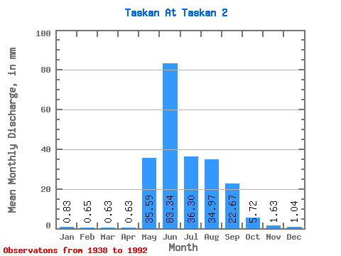
| Statistic | Jan | Feb | Mar | Apr | May | Jun | Jul | Aug | Sep | Oct | Nov | Dec | Annual |
|---|---|---|---|---|---|---|---|---|---|---|---|---|---|
| Mean | 0.83 | 0.65 | 0.63 | 0.63 | 35.59 | 83.34 | 36.30 | 34.97 | 22.67 | 5.72 | 1.63 | 1.04 | 224.32 |
| Standard Deviation | 0.24 | 0.18 | 0.20 | 0.19 | 22.73 | 45.70 | 18.18 | 18.46 | 13.88 | 3.35 | 0.57 | 0.25 | 56.86 |
| Min | 0.35 | 0.26 | 0.24 | 0.33 | 1.64 | 28.08 | 10.90 | 10.90 | 5.93 | 1.79 | 0.89 | 0.52 | 111.02 |
| Max | 1.43 | 1.13 | 1.27 | 1.21 | 107.17 | 216.56 | 84.34 | 101.26 | 81.11 | 21.46 | 4.34 | 1.65 | 325.94 |
| Coefficient of Variation | 0.28 | 0.28 | 0.31 | 0.30 | 0.64 | 0.55 | 0.50 | 0.53 | 0.61 | 0.58 | 0.35 | 0.24 | 0.25 |
 Return to R-Arctic Net Home Page