|
|
|||||||||||||||||
| Point ID: 5884 | Downloads | Plots | Site Data | Code: 1238 |
|
|
|||||||||||||||||
| Download | |
|---|---|
| Site Descriptor Information | Site Time Series Data |
| Link to all available data | |
| View: | Time Series | All |
| Units: | mm |
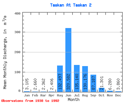
| Statistic | Jan | Feb | Mar | Apr | May | Jun | Jul | Aug | Sep | Oct | Nov | Dec | Annual |
|---|---|---|---|---|---|---|---|---|---|---|---|---|---|
| Mean | 3.10 | 2.66 | 2.36 | 2.41 | 132.50 | 320.58 | 135.14 | 130.18 | 87.19 | 21.30 | 6.28 | 3.86 | 70.86 |
| Standard Deviation | 0.88 | 0.76 | 0.73 | 0.72 | 84.64 | 175.78 | 67.67 | 68.72 | 53.40 | 12.46 | 2.21 | 0.93 | 17.96 |
| Min | 1.30 | 1.08 | 0.91 | 1.26 | 6.11 | 108.00 | 40.60 | 40.60 | 22.80 | 6.67 | 3.41 | 1.92 | 35.07 |
| Max | 5.34 | 4.60 | 4.73 | 4.66 | 399.00 | 833.00 | 314.00 | 377.00 | 312.00 | 79.90 | 16.70 | 6.15 | 102.97 |
| Coefficient of Variation | 0.28 | 0.28 | 0.31 | 0.30 | 0.64 | 0.55 | 0.50 | 0.53 | 0.61 | 0.58 | 0.35 | 0.24 | 0.25 |
 Return to R-Arctic Net Home Page