|
|
|||||||||||||||||
| Point ID: 5859 | Downloads | Plots | Site Data | Code: 1024 |
|
|
|||||||||||||||||
| Download | |
|---|---|
| Site Descriptor Information | Site Time Series Data |
| Link to all available data | |
| View: | Time Series | All |
| Units: | m3/s |
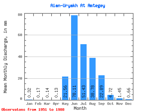
| Statistic | Jan | Feb | Mar | Apr | May | Jun | Jul | Aug | Sep | Oct | Nov | Dec | Annual |
|---|---|---|---|---|---|---|---|---|---|---|---|---|---|
| Mean | 0.32 | 0.17 | 0.14 | 0.13 | 21.56 | 78.11 | 51.42 | 38.78 | 22.89 | 4.72 | 1.45 | 0.66 | 220.22 |
| Standard Deviation | 0.15 | 0.07 | 0.06 | 0.06 | 22.05 | 43.11 | 22.13 | 15.77 | 13.91 | 1.61 | 0.45 | 0.26 | 51.14 |
| Min | 0.14 | 0.09 | 0.06 | 0.04 | 0.78 | 11.88 | 18.88 | 11.90 | 5.80 | 1.77 | 0.70 | 0.25 | 123.08 |
| Max | 0.72 | 0.42 | 0.33 | 0.27 | 101.69 | 210.94 | 141.18 | 80.12 | 65.07 | 9.27 | 2.29 | 1.27 | 321.59 |
| Coefficient of Variation | 0.47 | 0.44 | 0.41 | 0.44 | 1.02 | 0.55 | 0.43 | 0.41 | 0.61 | 0.34 | 0.31 | 0.40 | 0.23 |
 Return to R-Arctic Net Home Page