|
|
|||||||||||||||||
| Point ID: 5859 | Downloads | Plots | Site Data | Code: 1024 |
|
|
|||||||||||||||||
| Download | |
|---|---|
| Site Descriptor Information | Site Time Series Data |
| Link to all available data | |
| View: | Time Series | All |
| Units: | mm |
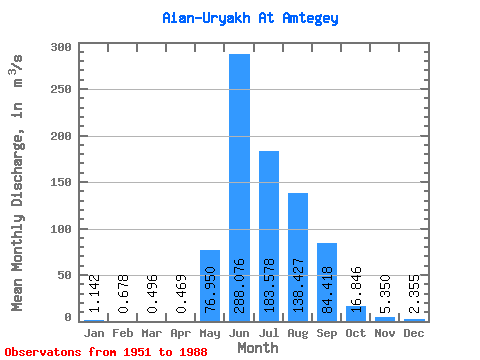
| Statistic | Jan | Feb | Mar | Apr | May | Jun | Jul | Aug | Sep | Oct | Nov | Dec | Annual |
|---|---|---|---|---|---|---|---|---|---|---|---|---|---|
| Mean | 1.14 | 0.68 | 0.50 | 0.47 | 76.95 | 288.08 | 183.58 | 138.43 | 84.42 | 16.85 | 5.35 | 2.35 | 66.71 |
| Standard Deviation | 0.54 | 0.30 | 0.20 | 0.21 | 78.73 | 159.00 | 79.02 | 56.28 | 51.29 | 5.74 | 1.67 | 0.94 | 15.49 |
| Min | 0.49 | 0.34 | 0.21 | 0.14 | 2.80 | 43.80 | 67.40 | 42.50 | 21.40 | 6.32 | 2.57 | 0.89 | 37.28 |
| Max | 2.56 | 1.63 | 1.17 | 1.00 | 363.00 | 778.00 | 504.00 | 286.00 | 240.00 | 33.10 | 8.45 | 4.54 | 97.41 |
| Coefficient of Variation | 0.47 | 0.44 | 0.41 | 0.44 | 1.02 | 0.55 | 0.43 | 0.41 | 0.61 | 0.34 | 0.31 | 0.40 | 0.23 |
 Return to R-Arctic Net Home Page