|
|
|||||||||||||||||
| Point ID: 5853 | Downloads | Plots | Site Data | Code: 10MD001 |
|
|
|||||||||||||||||
| Download | |
|---|---|
| Site Descriptor Information | Site Time Series Data |
| Link to all available data | |
| View: | Time Series | All |
| Units: | m3/s |
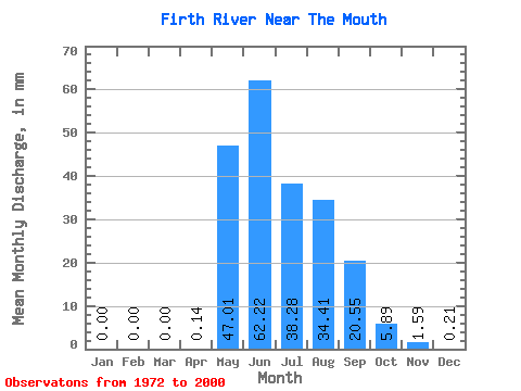
| Statistic | Jan | Feb | Mar | Apr | May | Jun | Jul | Aug | Sep | Oct | Nov | Dec | Annual |
|---|---|---|---|---|---|---|---|---|---|---|---|---|---|
| Mean | 0.00 | 0.00 | 0.00 | 0.14 | 47.01 | 62.22 | 38.28 | 34.41 | 20.55 | 5.89 | 1.59 | 0.21 | 203.07 |
| Standard Deviation | 0.00 | 0.00 | 0.00 | 0.28 | 38.50 | 27.63 | 13.86 | 14.69 | 8.06 | 2.39 | 0.95 | 0.26 | 50.95 |
| Min | 0.00 | 0.00 | 0.00 | 0.00 | 1.48 | 28.28 | 20.54 | 10.41 | 5.08 | 2.42 | 0.01 | 0.00 | 119.90 |
| Max | 0.00 | 0.00 | 0.00 | 1.03 | 141.17 | 157.52 | 75.51 | 78.32 | 36.36 | 10.46 | 3.95 | 1.10 | 323.43 |
| Coefficient of Variation | 1.99 | 0.82 | 0.44 | 0.36 | 0.43 | 0.39 | 0.41 | 0.60 | 1.25 | 0.25 |
 Return to R-Arctic Net Home Page