|
|
|||||||||||||||||
| Point ID: 5853 | Downloads | Plots | Site Data | Code: 10MD001 |
|
|
|||||||||||||||||
| Download | |
|---|---|
| Site Descriptor Information | Site Time Series Data |
| Link to all available data | |
| View: | Time Series | All |
| Units: | mm |
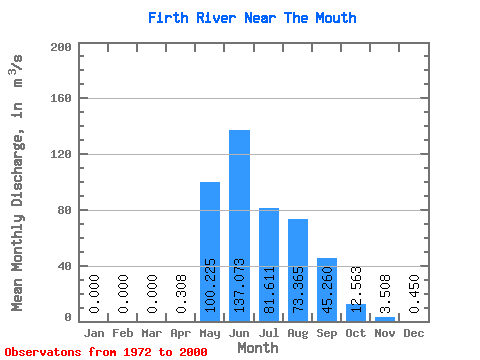
| Statistic | Jan | Feb | Mar | Apr | May | Jun | Jul | Aug | Sep | Oct | Nov | Dec | Annual |
|---|---|---|---|---|---|---|---|---|---|---|---|---|---|
| Mean | 0.00 | 0.00 | 0.00 | 0.31 | 100.22 | 137.07 | 81.61 | 73.36 | 45.26 | 12.56 | 3.51 | 0.45 | 36.74 |
| Standard Deviation | 0.00 | 0.00 | 0.00 | 0.61 | 82.10 | 60.86 | 29.55 | 31.32 | 17.75 | 5.10 | 2.10 | 0.56 | 9.22 |
| Min | 0.00 | 0.00 | 0.00 | 0.00 | 3.15 | 62.30 | 43.80 | 22.20 | 11.20 | 5.16 | 0.03 | 0.00 | 21.69 |
| Max | 0.00 | 0.00 | 0.00 | 2.28 | 301.00 | 347.00 | 161.00 | 167.00 | 80.10 | 22.30 | 8.70 | 2.35 | 58.52 |
| Coefficient of Variation | 1.99 | 0.82 | 0.44 | 0.36 | 0.43 | 0.39 | 0.41 | 0.60 | 1.25 | 0.25 |
 Return to R-Arctic Net Home Page