|
|
|||||||||||||||||
| Point ID: 5851 | Downloads | Plots | Site Data | Code: 10MB003 |
|
|
|||||||||||||||||
| Download | |
|---|---|
| Site Descriptor Information | Site Time Series Data |
| Link to all available data | |
| View: | Time Series | All |
| Units: | m3/s |
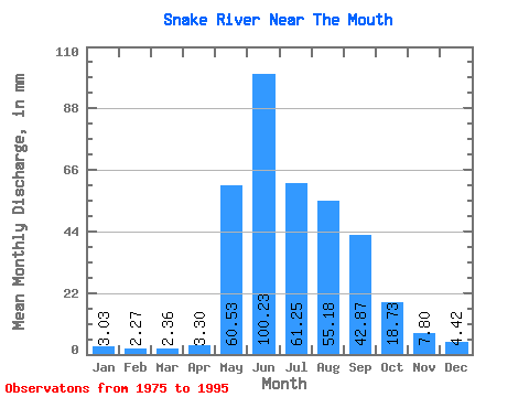
| Statistic | Jan | Feb | Mar | Apr | May | Jun | Jul | Aug | Sep | Oct | Nov | Dec | Annual |
|---|---|---|---|---|---|---|---|---|---|---|---|---|---|
| Mean | 3.03 | 2.29 | 2.36 | 3.30 | 60.52 | 100.23 | 61.24 | 55.17 | 42.87 | 18.72 | 7.80 | 4.42 | 352.47 |
| Standard Deviation | 0.66 | 0.45 | 0.32 | 3.35 | 24.64 | 29.98 | 21.65 | 19.50 | 19.41 | 6.49 | 3.11 | 1.21 | 49.75 |
| Min | 2.00 | 1.38 | 1.84 | 1.72 | 5.53 | 60.22 | 27.65 | 19.87 | 16.14 | 8.69 | 4.28 | 2.75 | 275.41 |
| Max | 4.21 | 3.20 | 3.01 | 16.99 | 94.38 | 156.80 | 114.81 | 110.31 | 83.49 | 33.96 | 18.79 | 7.96 | 429.06 |
| Coefficient of Variation | 0.22 | 0.20 | 0.14 | 1.01 | 0.41 | 0.30 | 0.35 | 0.35 | 0.45 | 0.35 | 0.40 | 0.27 | 0.14 |
 Return to R-Arctic Net Home Page