|
|
|||||||||||||||||
| Point ID: 5851 | Downloads | Plots | Site Data | Code: 10MB003 |
|
|
|||||||||||||||||
| Download | |
|---|---|
| Site Descriptor Information | Site Time Series Data |
| Link to all available data | |
| View: | Time Series | All |
| Units: | mm |
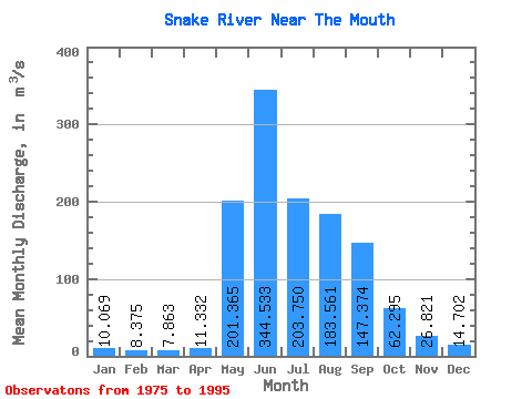
| Statistic | Jan | Feb | Mar | Apr | May | Jun | Jul | Aug | Sep | Oct | Nov | Dec | Annual |
|---|---|---|---|---|---|---|---|---|---|---|---|---|---|
| Mean | 10.07 | 8.38 | 7.86 | 11.33 | 201.37 | 344.53 | 203.75 | 183.56 | 147.37 | 62.30 | 26.82 | 14.70 | 99.51 |
| Standard Deviation | 2.20 | 1.66 | 1.06 | 11.51 | 81.98 | 103.05 | 72.02 | 64.86 | 66.72 | 21.59 | 10.68 | 4.03 | 14.04 |
| Min | 6.64 | 5.04 | 6.11 | 5.90 | 18.40 | 207.00 | 92.00 | 66.10 | 55.50 | 28.90 | 14.70 | 9.14 | 77.75 |
| Max | 14.00 | 11.70 | 10.00 | 58.40 | 314.00 | 539.00 | 382.00 | 367.00 | 287.00 | 113.00 | 64.60 | 26.50 | 121.13 |
| Coefficient of Variation | 0.22 | 0.20 | 0.14 | 1.01 | 0.41 | 0.30 | 0.35 | 0.35 | 0.45 | 0.35 | 0.40 | 0.27 | 0.14 |
 Return to R-Arctic Net Home Page