|
|
|||||||||||||||||
| Point ID: 5849 | Downloads | Plots | Site Data | Code: 10MA003 |
|
|
|||||||||||||||||
| Download | |
|---|---|
| Site Descriptor Information | Site Time Series Data |
| Link to all available data | |
| View: | Time Series | All |
| Units: | m3/s |
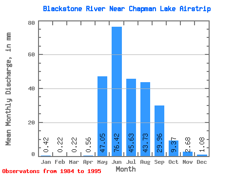
| Statistic | Jan | Feb | Mar | Apr | May | Jun | Jul | Aug | Sep | Oct | Nov | Dec | Annual |
|---|---|---|---|---|---|---|---|---|---|---|---|---|---|
| Mean | 0.42 | 0.23 | 0.21 | 0.56 | 47.05 | 76.42 | 45.62 | 43.73 | 29.96 | 9.37 | 2.68 | 1.08 | 256.31 |
| Standard Deviation | 0.25 | 0.11 | 0.14 | 0.66 | 31.50 | 21.83 | 11.10 | 16.00 | 10.13 | 2.89 | 1.38 | 0.82 | 51.27 |
| Min | 0.03 | 0.03 | 0.03 | 0.02 | 2.84 | 49.32 | 26.54 | 24.17 | 15.80 | 4.64 | 0.65 | 0.25 | 159.88 |
| Max | 1.00 | 0.42 | 0.42 | 2.19 | 104.51 | 116.98 | 60.43 | 69.44 | 50.01 | 12.68 | 5.53 | 2.89 | 336.38 |
| Coefficient of Variation | 0.59 | 0.48 | 0.64 | 1.19 | 0.67 | 0.29 | 0.24 | 0.37 | 0.34 | 0.31 | 0.51 | 0.76 | 0.20 |
 Return to R-Arctic Net Home Page