|
|
|||||||||||||||||
| Point ID: 5849 | Downloads | Plots | Site Data | Code: 10MA003 |
|
|
|||||||||||||||||
| Download | |
|---|---|
| Site Descriptor Information | Site Time Series Data |
| Link to all available data | |
| View: | Time Series | All |
| Units: | mm |
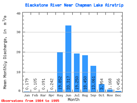
| Statistic | Jan | Feb | Mar | Apr | May | Jun | Jul | Aug | Sep | Oct | Nov | Dec | Annual |
|---|---|---|---|---|---|---|---|---|---|---|---|---|---|
| Mean | 0.18 | 0.10 | 0.09 | 0.24 | 19.85 | 33.32 | 19.25 | 18.45 | 13.06 | 3.95 | 1.17 | 0.46 | 9.18 |
| Standard Deviation | 0.11 | 0.05 | 0.06 | 0.29 | 13.29 | 9.52 | 4.69 | 6.75 | 4.42 | 1.22 | 0.60 | 0.35 | 1.84 |
| Min | 0.01 | 0.01 | 0.01 | 0.01 | 1.20 | 21.50 | 11.20 | 10.20 | 6.89 | 1.96 | 0.28 | 0.11 | 5.72 |
| Max | 0.42 | 0.20 | 0.18 | 0.96 | 44.10 | 51.00 | 25.50 | 29.30 | 21.80 | 5.35 | 2.41 | 1.22 | 12.04 |
| Coefficient of Variation | 0.59 | 0.48 | 0.64 | 1.19 | 0.67 | 0.29 | 0.24 | 0.37 | 0.34 | 0.31 | 0.51 | 0.76 | 0.20 |
 Return to R-Arctic Net Home Page