|
|
|||||||||||||||||
| Point ID: 5848 | Downloads | Plots | Site Data | Code: 10MA002 |
|
|
|||||||||||||||||
| Download | |
|---|---|
| Site Descriptor Information | Site Time Series Data |
| Link to all available data | |
| View: | Time Series | All |
| Units: | m3/s |
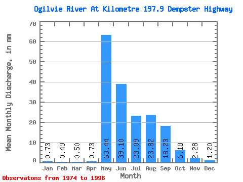
| Statistic | Jan | Feb | Mar | Apr | May | Jun | Jul | Aug | Sep | Oct | Nov | Dec | Annual |
|---|---|---|---|---|---|---|---|---|---|---|---|---|---|
| Mean | 0.73 | 0.49 | 0.50 | 0.73 | 63.43 | 39.10 | 23.08 | 23.81 | 18.23 | 6.18 | 2.28 | 1.20 | 178.47 |
| Standard Deviation | 0.34 | 0.22 | 0.22 | 0.62 | 23.82 | 13.98 | 14.28 | 11.96 | 9.25 | 2.17 | 0.82 | 0.48 | 41.01 |
| Min | 0.35 | 0.17 | 0.15 | 0.26 | 10.00 | 20.03 | 10.84 | 6.83 | 7.76 | 2.14 | 1.26 | 0.53 | 105.48 |
| Max | 1.81 | 1.18 | 1.26 | 3.03 | 100.49 | 68.03 | 62.37 | 48.51 | 47.19 | 9.95 | 4.23 | 2.21 | 275.89 |
| Coefficient of Variation | 0.47 | 0.45 | 0.45 | 0.85 | 0.38 | 0.36 | 0.62 | 0.50 | 0.51 | 0.35 | 0.36 | 0.40 | 0.23 |
 Return to R-Arctic Net Home Page