|
|
|||||||||||||||||
| Point ID: 5848 | Downloads | Plots | Site Data | Code: 10MA002 |
|
|
|||||||||||||||||
| Download | |
|---|---|
| Site Descriptor Information | Site Time Series Data |
| Link to all available data | |
| View: | Time Series | All |
| Units: | mm |
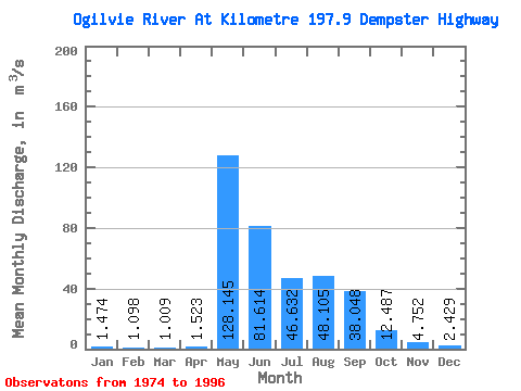
| Statistic | Jan | Feb | Mar | Apr | May | Jun | Jul | Aug | Sep | Oct | Nov | Dec | Annual |
|---|---|---|---|---|---|---|---|---|---|---|---|---|---|
| Mean | 1.47 | 1.10 | 1.01 | 1.52 | 128.15 | 81.61 | 46.63 | 48.10 | 38.05 | 12.49 | 4.75 | 2.43 | 30.59 |
| Standard Deviation | 0.69 | 0.50 | 0.45 | 1.29 | 48.12 | 29.19 | 28.85 | 24.16 | 19.31 | 4.38 | 1.71 | 0.96 | 7.03 |
| Min | 0.70 | 0.38 | 0.31 | 0.55 | 20.20 | 41.80 | 21.90 | 13.80 | 16.20 | 4.32 | 2.63 | 1.07 | 18.08 |
| Max | 3.65 | 2.62 | 2.54 | 6.33 | 203.00 | 142.00 | 126.00 | 98.00 | 98.50 | 20.10 | 8.82 | 4.47 | 47.29 |
| Coefficient of Variation | 0.47 | 0.45 | 0.45 | 0.85 | 0.38 | 0.36 | 0.62 | 0.50 | 0.51 | 0.35 | 0.36 | 0.40 | 0.23 |
 Return to R-Arctic Net Home Page