|
|
|||||||||||||||||
| Point ID: 5846 | Downloads | Plots | Site Data | Code: 10BD001 |
|
|
|||||||||||||||||
| Download | |
|---|---|
| Site Descriptor Information | Site Time Series Data |
| Link to all available data | |
| View: | Time Series | All |
| Units: | m3/s |
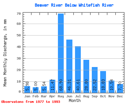
| Statistic | Jan | Feb | Mar | Apr | May | Jun | Jul | Aug | Sep | Oct | Nov | Dec | Annual |
|---|---|---|---|---|---|---|---|---|---|---|---|---|---|
| Mean | 5.98 | 5.04 | 5.54 | 11.47 | 68.89 | 46.31 | 40.61 | 28.80 | 22.52 | 18.83 | 10.54 | 7.70 | 270.99 |
| Standard Deviation | 1.24 | 0.93 | 0.80 | 5.80 | 26.00 | 26.19 | 19.69 | 9.08 | 8.12 | 7.25 | 3.41 | 1.60 | 70.86 |
| Min | 3.32 | 2.94 | 4.45 | 4.77 | 34.69 | 21.75 | 14.75 | 9.49 | 10.65 | 10.63 | 5.59 | 5.11 | 163.94 |
| Max | 8.17 | 6.37 | 6.92 | 25.28 | 110.72 | 132.09 | 88.29 | 47.09 | 45.57 | 36.67 | 18.87 | 10.26 | 408.12 |
| Coefficient of Variation | 0.21 | 0.18 | 0.14 | 0.51 | 0.38 | 0.57 | 0.48 | 0.32 | 0.36 | 0.39 | 0.32 | 0.21 | 0.26 |
 Return to R-Arctic Net Home Page