|
|
|||||||||||||||||
| Point ID: 5846 | Downloads | Plots | Site Data | Code: 10BD001 |
|
|
|||||||||||||||||
| Download | |
|---|---|
| Site Descriptor Information | Site Time Series Data |
| Link to all available data | |
| View: | Time Series | All |
| Units: | mm |
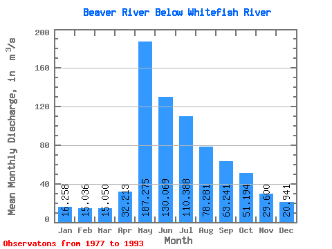
| Statistic | Jan | Feb | Mar | Apr | May | Jun | Jul | Aug | Sep | Oct | Nov | Dec | Annual |
|---|---|---|---|---|---|---|---|---|---|---|---|---|---|
| Mean | 16.26 | 15.04 | 15.05 | 32.21 | 187.28 | 130.07 | 110.39 | 78.28 | 63.24 | 51.19 | 29.60 | 20.94 | 62.51 |
| Standard Deviation | 3.38 | 2.79 | 2.19 | 16.30 | 70.67 | 73.56 | 53.52 | 24.69 | 22.81 | 19.72 | 9.59 | 4.34 | 16.35 |
| Min | 9.03 | 8.78 | 12.10 | 13.40 | 94.30 | 61.10 | 40.10 | 25.80 | 29.90 | 28.90 | 15.70 | 13.90 | 37.82 |
| Max | 22.20 | 19.00 | 18.80 | 71.00 | 301.00 | 371.00 | 240.00 | 128.00 | 128.00 | 99.70 | 53.00 | 27.90 | 94.14 |
| Coefficient of Variation | 0.21 | 0.18 | 0.14 | 0.51 | 0.38 | 0.57 | 0.48 | 0.32 | 0.36 | 0.39 | 0.32 | 0.21 | 0.26 |
 Return to R-Arctic Net Home Page