|
|
|||||||||||||||||
| Point ID: 5845 | Downloads | Plots | Site Data | Code: 10AD002 |
|
|
|||||||||||||||||
| Download | |
|---|---|
| Site Descriptor Information | Site Time Series Data |
| Link to all available data | |
| View: | Time Series | All |
| Units: | m3/s |
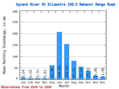
| Statistic | Jan | Feb | Mar | Apr | May | Jun | Jul | Aug | Sep | Oct | Nov | Dec | Annual |
|---|---|---|---|---|---|---|---|---|---|---|---|---|---|
| Mean | 8.04 | 6.07 | 5.70 | 5.81 | 61.37 | 206.86 | 153.79 | 81.01 | 55.00 | 37.55 | 16.86 | 11.47 | 648.45 |
| Standard Deviation | 1.39 | 1.04 | 0.97 | 0.80 | 30.11 | 31.77 | 38.63 | 11.70 | 15.23 | 12.35 | 4.62 | 2.25 | 68.18 |
| Min | 5.54 | 4.54 | 3.99 | 4.22 | 24.91 | 163.96 | 103.38 | 60.29 | 35.20 | 21.42 | 7.17 | 7.09 | 499.71 |
| Max | 10.26 | 8.05 | 7.15 | 6.84 | 119.95 | 286.93 | 249.12 | 107.25 | 88.25 | 60.53 | 24.71 | 14.57 | 772.40 |
| Coefficient of Variation | 0.17 | 0.17 | 0.17 | 0.14 | 0.49 | 0.15 | 0.25 | 0.14 | 0.28 | 0.33 | 0.27 | 0.20 | 0.10 |
 Return to R-Arctic Net Home Page