|
|
|||||||||||||||||
| Point ID: 5845 | Downloads | Plots | Site Data | Code: 10AD002 |
|
|
|||||||||||||||||
| Download | |
|---|---|
| Site Descriptor Information | Site Time Series Data |
| Link to all available data | |
|
|
| View: | Statistics | Time Series |
| Units: | m3/s |
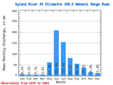
| Statistic | Jan | Feb | Mar | Apr | May | Jun | Jul | Aug | Sep | Oct | Nov | Dec | Annual |
|---|---|---|---|---|---|---|---|---|---|---|---|---|---|
| Mean | 8.04 | 6.07 | 5.70 | 5.81 | 61.37 | 206.86 | 153.79 | 81.01 | 55.00 | 37.55 | 16.86 | 11.47 | 648.45 |
| Standard Deviation | 1.39 | 1.04 | 0.97 | 0.80 | 30.11 | 31.77 | 38.63 | 11.70 | 15.23 | 12.35 | 4.62 | 2.25 | 68.18 |
| Min | 5.54 | 4.54 | 3.99 | 4.22 | 24.91 | 163.96 | 103.38 | 60.29 | 35.20 | 21.42 | 7.17 | 7.09 | 499.71 |
| Max | 10.26 | 8.05 | 7.15 | 6.84 | 119.95 | 286.93 | 249.12 | 107.25 | 88.25 | 60.53 | 24.71 | 14.57 | 772.40 |
| Coefficient of Variation | 0.17 | 0.17 | 0.17 | 0.14 | 0.49 | 0.15 | 0.25 | 0.14 | 0.28 | 0.33 | 0.27 | 0.20 | 0.10 |
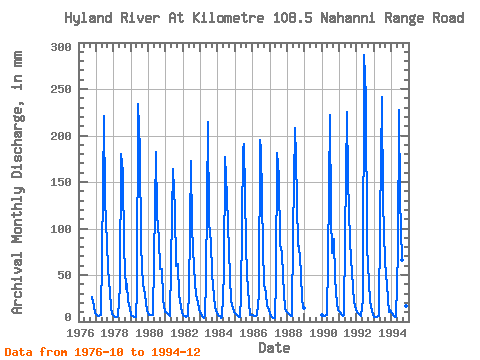
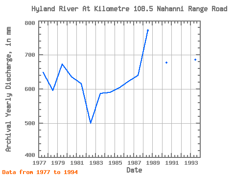
| Year | Jan | Feb | Mar | Apr | May | Jun | Jul | Aug | Sep | Oct | Nov | Dec | Annual | 1976 | 27.78 | 16.64 | 9.23 | 1977 | 6.99 | 5.83 | 5.95 | 6.57 | 71.87 | 220.62 | 134.52 | 85.70 | 57.02 | 32.01 | 15.43 | 8.54 | 649.72 | 1978 | 6.29 | 4.99 | 4.89 | 5.47 | 39.61 | 179.63 | 165.66 | 80.22 | 35.20 | 41.48 | 21.82 | 13.45 | 596.36 | 1979 | 7.50 | 5.45 | 5.49 | 5.18 | 34.25 | 233.88 | 190.57 | 84.33 | 39.66 | 37.12 | 20.86 | 11.75 | 674.21 | 1980 | 7.69 | 6.62 | 6.73 | 6.57 | 67.01 | 182.04 | 119.70 | 91.18 | 56.18 | 58.42 | 24.71 | 10.91 | 635.74 | 1981 | 10.24 | 8.05 | 7.15 | 6.22 | 119.95 | 163.96 | 123.81 | 61.28 | 62.33 | 28.90 | 16.03 | 10.43 | 616.13 | 1982 | 7.56 | 5.66 | 5.28 | 6.16 | 33.13 | 172.40 | 103.38 | 60.29 | 41.59 | 30.77 | 20.37 | 13.70 | 499.71 | 1983 | 8.81 | 5.41 | 4.27 | 6.18 | 47.71 | 214.59 | 109.86 | 87.81 | 51.48 | 28.03 | 15.55 | 8.93 | 587.98 | 1984 | 7.20 | 5.61 | 4.33 | 4.57 | 52.56 | 177.22 | 138.26 | 107.25 | 47.62 | 23.17 | 13.98 | 11.06 | 590.67 | 1985 | 7.86 | 6.11 | 6.14 | 5.34 | 27.40 | 184.45 | 196.80 | 85.94 | 49.91 | 21.42 | 7.17 | 7.09 | 603.42 | 1986 | 6.81 | 5.28 | 6.14 | 6.49 | 30.77 | 195.30 | 191.82 | 81.21 | 40.39 | 31.26 | 16.16 | 14.07 | 623.41 | 1987 | 8.32 | 4.94 | 3.99 | 4.22 | 47.33 | 180.84 | 160.68 | 84.82 | 73.66 | 49.20 | 13.74 | 11.15 | 640.72 | 1988 | 8.92 | 7.32 | 6.78 | 6.37 | 96.91 | 208.57 | 183.10 | 83.95 | 81.62 | 54.81 | 22.30 | 14.57 | 772.40 | 1990 | 7.22 | 5.87 | 6.23 | 6.69 | 67.39 | 221.83 | 118.70 | 76.48 | 88.25 | 48.20 | 18.93 | 13.08 | 678.20 | 1991 | 10.05 | 7.25 | 6.43 | 6.84 | 92.80 | 225.44 | 158.19 | 89.06 | 68.00 | 38.49 | 21.46 | 13.33 | 735.29 | 1992 | 10.26 | 7.92 | 6.80 | 5.47 | 24.91 | 286.93 | 249.12 | 82.58 | 42.68 | 23.17 | 11.14 | 8.73 | 758.14 | 1993 | 5.54 | 4.54 | 5.11 | 5.73 | 110.86 | 241.12 | 133.28 | 66.76 | 50.63 | 41.10 | 10.21 | 13.08 | 686.09 | 1994 | 9.38 | 6.37 | 5.11 | 4.77 | 78.84 | 227.85 | 137.01 | 68.26 | 48.83 | 60.53 | 16.88 | 13.45 | 675.48 |
|---|
 Return to R-Arctic Net Home Page