|
|
|||||||||||||||||
| Point ID: 5835 | Downloads | Plots | Site Data | Code: 09FB002 |
|
|
|||||||||||||||||
| Download | |
|---|---|
| Site Descriptor Information | Site Time Series Data |
| Link to all available data | |
| View: | Time Series | All |
| Units: | m3/s |
| Statistic | Jan | Feb | Mar | Apr | May | Jun | Jul | Aug | Sep | Oct | Nov | Dec | Annual |
|---|---|---|---|---|---|---|---|---|---|---|---|---|---|
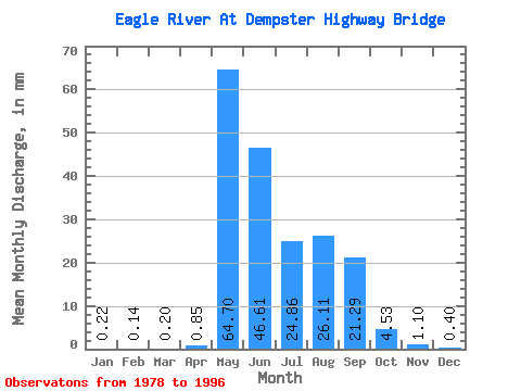
| Mean | 0.22 | 0.14 | 0.20 | 0.85 | 64.69 | 46.61 | 24.86 | 26.10 | 21.29 | 4.53 | 1.10 | 0.40 | 186.86 |
| Standard Deviation | 0.23 | 0.17 | 0.29 | 2.31 | 31.95 | 20.88 | 23.74 | 18.78 | 9.52 | 2.96 | 0.77 | 0.34 | 41.09 |
| Min | 0.00 | 0.00 | 0.00 | 0.00 | 13.78 | 17.03 | 4.73 | 2.83 | 5.61 | 0.94 | 0.04 | 0.00 | 122.57 |
| Max | 0.72 | 0.64 | 1.17 | 9.92 | 130.32 | 79.57 | 85.17 | 73.33 | 41.89 | 11.41 | 2.74 | 1.21 | 273.20 |
| Coefficient of Variation | 1.03 | 1.27 | 1.45 | 2.72 | 0.49 | 0.45 | 0.95 | 0.72 | 0.45 | 0.65 | 0.70 | 0.83 | 0.22 |
 Return to R-Arctic Net Home Page