|
|
|||||||||||||||||
| Point ID: 5835 | Downloads | Plots | Site Data | Code: 09FB002 |
|
|
|||||||||||||||||
| Download | |
|---|---|
| Site Descriptor Information | Site Time Series Data |
| Link to all available data | |
| View: | Time Series | All |
| Units: | mm |
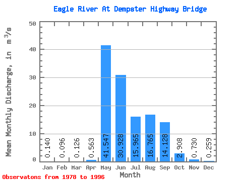
| Statistic | Jan | Feb | Mar | Apr | May | Jun | Jul | Aug | Sep | Oct | Nov | Dec | Annual |
|---|---|---|---|---|---|---|---|---|---|---|---|---|---|
| Mean | 0.14 | 0.10 | 0.13 | 0.56 | 41.55 | 30.93 | 15.96 | 16.77 | 14.13 | 2.91 | 0.73 | 0.26 | 10.18 |
| Standard Deviation | 0.14 | 0.12 | 0.18 | 1.53 | 20.52 | 13.86 | 15.25 | 12.06 | 6.32 | 1.90 | 0.51 | 0.21 | 2.24 |
| Min | 0.00 | 0.00 | 0.00 | 0.00 | 8.85 | 11.30 | 3.04 | 1.82 | 3.72 | 0.60 | 0.03 | 0.00 | 6.68 |
| Max | 0.46 | 0.45 | 0.75 | 6.58 | 83.70 | 52.80 | 54.70 | 47.10 | 27.80 | 7.33 | 1.82 | 0.78 | 14.89 |
| Coefficient of Variation | 1.03 | 1.27 | 1.45 | 2.72 | 0.49 | 0.45 | 0.95 | 0.72 | 0.45 | 0.65 | 0.70 | 0.83 | 0.22 |
 Return to R-Arctic Net Home Page