|
|
|||||||||||||||||
| Point ID: 5833 | Downloads | Plots | Site Data | Code: 09FA001 |
|
|
|||||||||||||||||
| Download | |
|---|---|
| Site Descriptor Information | Site Time Series Data |
| Link to all available data | |
| View: | Time Series | All |
| Units: | m3/s |
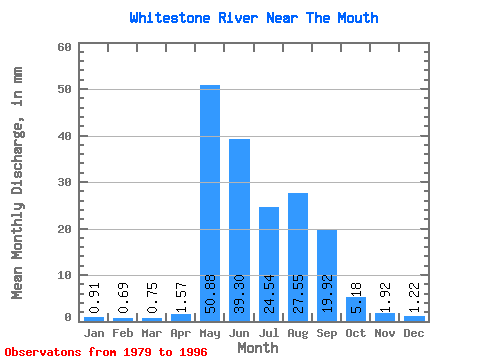
| Statistic | Jan | Feb | Mar | Apr | May | Jun | Jul | Aug | Sep | Oct | Nov | Dec | Annual |
|---|---|---|---|---|---|---|---|---|---|---|---|---|---|
| Mean | 0.91 | 0.69 | 0.75 | 1.57 | 50.87 | 39.30 | 24.53 | 27.55 | 19.92 | 5.18 | 1.92 | 1.22 | 171.67 |
| Standard Deviation | 0.26 | 0.20 | 0.17 | 2.42 | 25.56 | 20.35 | 20.11 | 14.65 | 11.04 | 2.20 | 0.80 | 0.38 | 57.03 |
| Min | 0.48 | 0.34 | 0.51 | 0.61 | 2.74 | 13.56 | 8.20 | 7.44 | 3.38 | 2.54 | 0.95 | 0.81 | 68.03 |
| Max | 1.40 | 1.03 | 1.14 | 11.02 | 100.67 | 77.41 | 68.44 | 48.15 | 49.68 | 11.14 | 4.58 | 2.32 | 272.53 |
| Coefficient of Variation | 0.28 | 0.29 | 0.23 | 1.54 | 0.50 | 0.52 | 0.82 | 0.53 | 0.55 | 0.42 | 0.42 | 0.31 | 0.33 |
 Return to R-Arctic Net Home Page