|
|
|||||||||||||||||
| Point ID: 5833 | Downloads | Plots | Site Data | Code: 09FA001 |
|
|
|||||||||||||||||
| Download | |
|---|---|
| Site Descriptor Information | Site Time Series Data |
| Link to all available data | |
| View: | Time Series | All |
| Units: | mm |
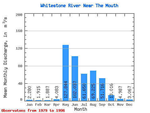
| Statistic | Jan | Feb | Mar | Apr | May | Jun | Jul | Aug | Sep | Oct | Nov | Dec | Annual |
|---|---|---|---|---|---|---|---|---|---|---|---|---|---|
| Mean | 2.28 | 1.92 | 1.89 | 4.08 | 127.84 | 102.04 | 61.65 | 69.22 | 51.72 | 13.02 | 4.99 | 3.07 | 36.61 |
| Standard Deviation | 0.64 | 0.55 | 0.44 | 6.30 | 64.23 | 52.85 | 50.52 | 36.81 | 28.65 | 5.53 | 2.08 | 0.96 | 12.16 |
| Min | 1.22 | 0.95 | 1.27 | 1.59 | 6.89 | 35.20 | 20.60 | 18.70 | 8.79 | 6.38 | 2.48 | 2.03 | 14.51 |
| Max | 3.51 | 2.84 | 2.87 | 28.60 | 253.00 | 201.00 | 172.00 | 121.00 | 129.00 | 28.00 | 11.90 | 5.83 | 58.12 |
| Coefficient of Variation | 0.28 | 0.29 | 0.23 | 1.54 | 0.50 | 0.52 | 0.82 | 0.53 | 0.55 | 0.42 | 0.42 | 0.31 | 0.33 |
 Return to R-Arctic Net Home Page