|
|
|||||||||||||||||
| Point ID: 5829 | Downloads | Plots | Site Data | Code: 09EB003 |
|
|
|||||||||||||||||
| Download | |
|---|---|
| Site Descriptor Information | Site Time Series Data |
| Link to all available data | |
| View: | Time Series | All |
| Units: | m3/s |
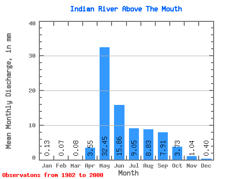
| Statistic | Jan | Feb | Mar | Apr | May | Jun | Jul | Aug | Sep | Oct | Nov | Dec | Annual |
|---|---|---|---|---|---|---|---|---|---|---|---|---|---|
| Mean | 0.13 | 0.07 | 0.08 | 3.55 | 32.45 | 15.87 | 9.05 | 8.83 | 7.91 | 3.73 | 1.04 | 0.40 | 83.34 |
| Standard Deviation | 0.20 | 0.14 | 0.20 | 3.65 | 12.77 | 6.34 | 5.02 | 6.57 | 4.53 | 2.24 | 1.00 | 0.54 | 29.19 |
| Min | 0.00 | 0.00 | 0.00 | 0.00 | 15.20 | 9.97 | 2.85 | 1.85 | 2.27 | 0.54 | 0.03 | 0.00 | 44.87 |
| Max | 0.76 | 0.57 | 0.84 | 12.03 | 59.35 | 30.71 | 21.83 | 29.80 | 19.27 | 7.55 | 3.73 | 1.92 | 133.44 |
| Coefficient of Variation | 1.58 | 2.15 | 2.40 | 1.03 | 0.39 | 0.40 | 0.56 | 0.74 | 0.57 | 0.60 | 0.96 | 1.34 | 0.35 |
 Return to R-Arctic Net Home Page