|
|
|||||||||||||||||
| Point ID: 5829 | Downloads | Plots | Site Data | Code: 09EB003 |
|
|
|||||||||||||||||
| Download | |
|---|---|
| Site Descriptor Information | Site Time Series Data |
| Link to all available data | |
| View: | Time Series | All |
| Units: | mm |
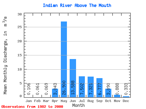
| Statistic | Jan | Feb | Mar | Apr | May | Jun | Jul | Aug | Sep | Oct | Nov | Dec | Annual |
|---|---|---|---|---|---|---|---|---|---|---|---|---|---|
| Mean | 0.11 | 0.06 | 0.07 | 3.04 | 26.90 | 13.59 | 7.50 | 7.32 | 6.78 | 3.09 | 0.89 | 0.33 | 5.86 |
| Standard Deviation | 0.17 | 0.13 | 0.17 | 3.13 | 10.59 | 5.43 | 4.16 | 5.45 | 3.88 | 1.86 | 0.86 | 0.45 | 2.05 |
| Min | 0.00 | 0.00 | 0.00 | 0.00 | 12.60 | 8.54 | 2.36 | 1.53 | 1.94 | 0.45 | 0.03 | 0.00 | 3.16 |
| Max | 0.63 | 0.52 | 0.70 | 10.30 | 49.20 | 26.30 | 18.10 | 24.70 | 16.50 | 6.26 | 3.19 | 1.59 | 9.39 |
| Coefficient of Variation | 1.58 | 2.15 | 2.40 | 1.03 | 0.39 | 0.40 | 0.56 | 0.74 | 0.57 | 0.60 | 0.96 | 1.34 | 0.35 |
 Return to R-Arctic Net Home Page