|
|
|||||||||||||||||
| Point ID: 5819 | Downloads | Plots | Site Data | Code: 09DC002 |
|
|
|||||||||||||||||
| Download | |
|---|---|
| Site Descriptor Information | Site Time Series Data |
| Link to all available data | |
| View: | Time Series | All |
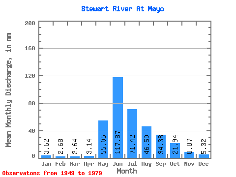
| Units: | m3/s |
| Statistic | Jan | Feb | Mar | Apr | May | Jun | Jul | Aug | Sep | Oct | Nov | Dec | Annual |
|---|---|---|---|---|---|---|---|---|---|---|---|---|---|
| Mean | 3.62 | 2.70 | 2.64 | 3.14 | 55.04 | 117.87 | 71.41 | 46.49 | 34.38 | 21.94 | 8.87 | 5.32 | 368.09 |
| Standard Deviation | 1.16 | 0.83 | 0.74 | 0.94 | 18.13 | 40.45 | 22.04 | 12.61 | 7.97 | 7.41 | 3.25 | 1.44 | 77.86 |
| Min | 1.62 | 1.52 | 1.31 | 1.61 | 13.90 | 58.16 | 35.51 | 29.15 | 19.85 | 13.14 | 3.34 | 3.46 | 227.56 |
| Max | 5.88 | 4.37 | 3.96 | 5.39 | 92.37 | 242.79 | 117.80 | 79.49 | 52.00 | 39.83 | 16.24 | 7.88 | 561.53 |
| Coefficient of Variation | 0.32 | 0.31 | 0.28 | 0.30 | 0.33 | 0.34 | 0.31 | 0.27 | 0.23 | 0.34 | 0.37 | 0.27 | 0.21 |
 Return to R-Arctic Net Home Page