|
|
|||||||||||||||||
| Point ID: 5819 | Downloads | Plots | Site Data | Code: 09DC002 |
|
|
|||||||||||||||||
| Download | |
|---|---|
| Site Descriptor Information | Site Time Series Data |
| Link to all available data | |
| View: | Time Series | All |
| Units: | mm |
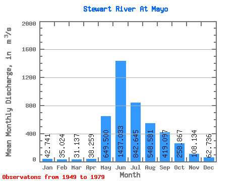
| Statistic | Jan | Feb | Mar | Apr | May | Jun | Jul | Aug | Sep | Oct | Nov | Dec | Annual |
|---|---|---|---|---|---|---|---|---|---|---|---|---|---|
| Mean | 42.74 | 35.02 | 31.14 | 38.26 | 649.50 | 1437.03 | 842.64 | 548.58 | 419.10 | 258.87 | 108.13 | 62.74 | 368.56 |
| Standard Deviation | 13.69 | 10.73 | 8.73 | 11.44 | 213.92 | 493.09 | 260.03 | 148.81 | 97.14 | 87.39 | 39.63 | 16.97 | 77.96 |
| Min | 19.10 | 19.70 | 15.50 | 19.60 | 164.00 | 709.00 | 419.00 | 344.00 | 242.00 | 155.00 | 40.70 | 40.80 | 227.85 |
| Max | 69.40 | 56.60 | 46.70 | 65.70 | 1090.00 | 2960.00 | 1390.00 | 938.00 | 634.00 | 470.00 | 198.00 | 93.00 | 562.24 |
| Coefficient of Variation | 0.32 | 0.31 | 0.28 | 0.30 | 0.33 | 0.34 | 0.31 | 0.27 | 0.23 | 0.34 | 0.37 | 0.27 | 0.21 |
 Return to R-Arctic Net Home Page