|
|
|||||||||||||||||
| Point ID: 5791 | Downloads | Plots | Site Data | Code: 09AC004 |
|
|
|||||||||||||||||
| Download | |
|---|---|
| Site Descriptor Information | Site Time Series Data |
| Link to all available data | |
| View: | Time Series | All |
| Units: | m3/s |
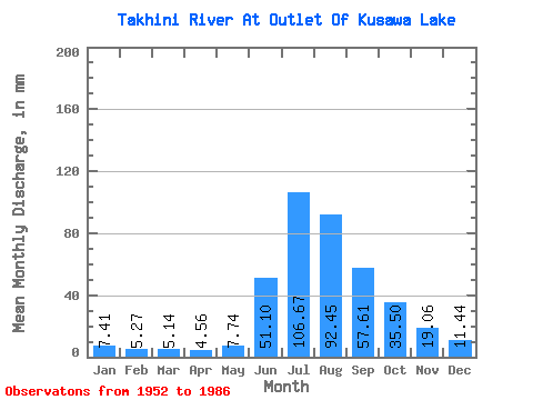
| Statistic | Jan | Feb | Mar | Apr | May | Jun | Jul | Aug | Sep | Oct | Nov | Dec | Annual |
|---|---|---|---|---|---|---|---|---|---|---|---|---|---|
| Mean | 7.41 | 5.32 | 5.14 | 4.56 | 7.74 | 51.10 | 106.66 | 92.44 | 57.61 | 35.49 | 19.06 | 11.44 | 398.35 |
| Standard Deviation | 1.65 | 1.01 | 0.97 | 0.83 | 2.27 | 22.45 | 21.25 | 15.02 | 11.40 | 8.48 | 4.30 | 2.66 | 54.42 |
| Min | 3.24 | 2.33 | 2.87 | 2.69 | 4.99 | 16.37 | 61.13 | 66.46 | 42.03 | 22.70 | 12.04 | 6.03 | 288.43 |
| Max | 10.40 | 7.37 | 7.70 | 7.07 | 14.15 | 105.72 | 153.97 | 128.31 | 80.88 | 53.10 | 28.09 | 16.71 | 504.97 |
| Coefficient of Variation | 0.22 | 0.19 | 0.19 | 0.18 | 0.29 | 0.44 | 0.20 | 0.16 | 0.20 | 0.24 | 0.23 | 0.23 | 0.14 |
 Return to R-Arctic Net Home Page