|
|
|||||||||||||||||
| Point ID: 5791 | Downloads | Plots | Site Data | Code: 09AC004 |
|
|
|||||||||||||||||
| Download | |
|---|---|
| Site Descriptor Information | Site Time Series Data |
| Link to all available data | |
| View: | Time Series | All |
| Units: | mm |
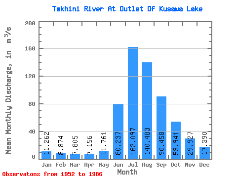
| Statistic | Jan | Feb | Mar | Apr | May | Jun | Jul | Aug | Sep | Oct | Nov | Dec | Annual |
|---|---|---|---|---|---|---|---|---|---|---|---|---|---|
| Mean | 11.26 | 8.87 | 7.80 | 7.16 | 11.76 | 80.24 | 162.10 | 140.48 | 90.46 | 53.94 | 29.93 | 17.39 | 51.37 |
| Standard Deviation | 2.50 | 1.69 | 1.47 | 1.30 | 3.45 | 35.25 | 32.30 | 22.83 | 17.91 | 12.89 | 6.75 | 4.04 | 7.02 |
| Min | 4.92 | 3.89 | 4.36 | 4.23 | 7.58 | 25.70 | 92.90 | 101.00 | 66.00 | 34.50 | 18.90 | 9.16 | 37.20 |
| Max | 15.80 | 12.30 | 11.70 | 11.10 | 21.50 | 166.00 | 234.00 | 195.00 | 127.00 | 80.70 | 44.10 | 25.40 | 65.12 |
| Coefficient of Variation | 0.22 | 0.19 | 0.19 | 0.18 | 0.29 | 0.44 | 0.20 | 0.16 | 0.20 | 0.24 | 0.23 | 0.23 | 0.14 |
 Return to R-Arctic Net Home Page