|
|
|||||||||||||||||
| Point ID: 5790 | Downloads | Plots | Site Data | Code: 09AC001 |
|
|
|||||||||||||||||
| Download | |
|---|---|
| Site Descriptor Information | Site Time Series Data |
| Link to all available data | |
| View: | Time Series | All |
| Units: | m3/s |
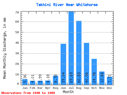
| Statistic | Jan | Feb | Mar | Apr | May | Jun | Jul | Aug | Sep | Oct | Nov | Dec | Annual |
|---|---|---|---|---|---|---|---|---|---|---|---|---|---|
| Mean | 5.36 | 4.04 | 3.99 | 4.18 | 8.78 | 39.04 | 69.68 | 60.83 | 40.06 | 24.77 | 12.66 | 7.72 | 277.12 |
| Standard Deviation | 1.16 | 0.92 | 0.82 | 0.88 | 2.86 | 14.62 | 12.91 | 10.31 | 11.74 | 6.49 | 3.23 | 1.72 | 41.76 |
| Min | 2.29 | 1.67 | 2.30 | 2.83 | 5.63 | 16.28 | 39.46 | 42.91 | 26.85 | 14.71 | 7.45 | 3.98 | 194.11 |
| Max | 8.70 | 6.53 | 6.59 | 7.19 | 16.55 | 76.02 | 104.97 | 98.84 | 106.42 | 49.04 | 20.39 | 12.14 | 415.08 |
| Coefficient of Variation | 0.22 | 0.23 | 0.20 | 0.21 | 0.33 | 0.38 | 0.18 | 0.17 | 0.29 | 0.26 | 0.26 | 0.22 | 0.15 |
 Return to R-Arctic Net Home Page