|
|
|||||||||||||||||
| Point ID: 5790 | Downloads | Plots | Site Data | Code: 09AC001 |
|
|
|||||||||||||||||
| Download | |
|---|---|
| Site Descriptor Information | Site Time Series Data |
| Link to all available data | |
| View: | Time Series | All |
| Units: | mm |
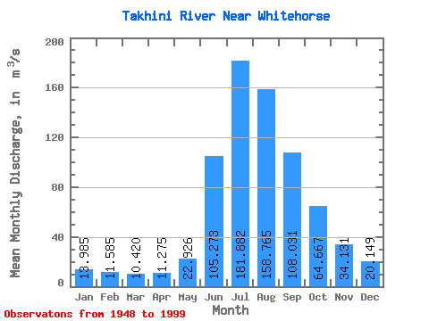
| Statistic | Jan | Feb | Mar | Apr | May | Jun | Jul | Aug | Sep | Oct | Nov | Dec | Annual |
|---|---|---|---|---|---|---|---|---|---|---|---|---|---|
| Mean | 13.98 | 11.59 | 10.42 | 11.28 | 22.93 | 105.27 | 181.88 | 158.76 | 108.03 | 64.67 | 34.13 | 20.15 | 61.38 |
| Standard Deviation | 3.03 | 2.63 | 2.14 | 2.37 | 7.46 | 39.43 | 33.69 | 26.90 | 31.67 | 16.94 | 8.71 | 4.50 | 9.25 |
| Min | 5.99 | 4.77 | 6.01 | 7.62 | 14.70 | 43.90 | 103.00 | 112.00 | 72.40 | 38.40 | 20.10 | 10.40 | 42.99 |
| Max | 22.70 | 18.70 | 17.20 | 19.40 | 43.20 | 205.00 | 274.00 | 258.00 | 287.00 | 128.00 | 55.00 | 31.70 | 91.93 |
| Coefficient of Variation | 0.22 | 0.23 | 0.20 | 0.21 | 0.33 | 0.38 | 0.18 | 0.17 | 0.29 | 0.26 | 0.26 | 0.22 | 0.15 |
 Return to R-Arctic Net Home Page