|
|
|||||||||||||||||
| Point ID: 5601 | Downloads | Plots | Site Data | Other Close Sites | Code: 06DD002 |
|
|
|||||||||||||||||
| Download | |
|---|---|
| Site Descriptor Information | Site Time Series Data |
| Link to all available data | |
| View: | Time Series | All |
| Units: | m3/s |
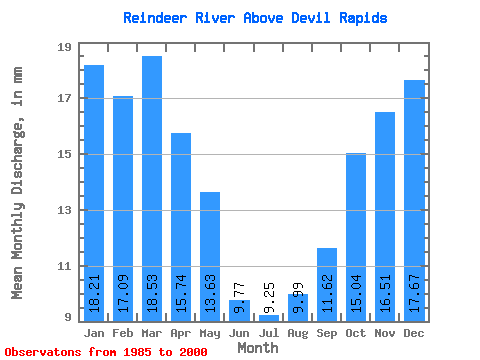
| Statistic | Jan | Feb | Mar | Apr | May | Jun | Jul | Aug | Sep | Oct | Nov | Dec | Annual |
|---|---|---|---|---|---|---|---|---|---|---|---|---|---|
| Mean | 18.21 | 17.23 | 18.52 | 15.74 | 13.63 | 9.77 | 9.24 | 9.98 | 11.62 | 15.03 | 16.51 | 17.67 | 174.75 |
| Standard Deviation | 5.17 | 3.71 | 3.49 | 2.32 | 2.97 | 4.31 | 4.52 | 5.83 | 5.52 | 8.82 | 7.36 | 5.65 | 43.47 |
| Min | 8.42 | 10.25 | 11.97 | 9.99 | 8.12 | 1.33 | 0.80 | 1.12 | 1.32 | 1.38 | 4.26 | 5.71 | 75.02 |
| Max | 24.79 | 21.93 | 22.80 | 19.12 | 19.84 | 16.58 | 17.90 | 21.75 | 20.47 | 41.12 | 36.12 | 25.00 | 230.05 |
| Coefficient of Variation | 0.28 | 0.21 | 0.19 | 0.15 | 0.22 | 0.44 | 0.49 | 0.58 | 0.47 | 0.59 | 0.45 | 0.32 | 0.25 |
| Other Close Sites | ||||||
|---|---|---|---|---|---|---|
| PointID | Latitude | Longitude | Drainage Area | Source | Name | |
| 5597 | "REINDEER RIVER AT OUTLET OF REINDEER LAKE" | 56.23 | 841997 | Hydat | ||
 Return to R-Arctic Net Home Page