|
|
|||||||||||||||||
| Point ID: 5601 | Downloads | Plots | Site Data | Other Close Sites | Code: 06DD002 |
|
|
|||||||||||||||||
| Download | |
|---|---|
| Site Descriptor Information | Site Time Series Data |
| Link to all available data | |
| View: | Time Series | All |
| Units: | mm |
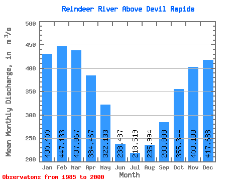
| Statistic | Jan | Feb | Mar | Apr | May | Jun | Jul | Aug | Sep | Oct | Nov | Dec | Annual |
|---|---|---|---|---|---|---|---|---|---|---|---|---|---|
| Mean | 430.40 | 447.13 | 437.87 | 384.47 | 322.13 | 238.49 | 218.52 | 235.99 | 283.89 | 355.34 | 403.19 | 417.69 | 350.51 |
| Standard Deviation | 122.26 | 96.14 | 82.56 | 56.62 | 70.30 | 105.23 | 106.83 | 137.87 | 134.73 | 208.42 | 179.74 | 133.55 | 87.19 |
| Min | 199.00 | 266.00 | 283.00 | 244.00 | 192.00 | 32.40 | 18.80 | 26.60 | 32.20 | 32.50 | 104.00 | 135.00 | 150.46 |
| Max | 586.00 | 569.00 | 539.00 | 467.00 | 469.00 | 405.00 | 423.00 | 514.00 | 500.00 | 972.00 | 882.00 | 591.00 | 461.42 |
| Coefficient of Variation | 0.28 | 0.21 | 0.19 | 0.15 | 0.22 | 0.44 | 0.49 | 0.58 | 0.47 | 0.59 | 0.45 | 0.32 | 0.25 |
| Other Close Sites | ||||||
|---|---|---|---|---|---|---|
| PointID | Latitude | Longitude | Drainage Area | Source | Name | |
| 5597 | "REINDEER RIVER AT OUTLET OF REINDEER LAKE" | 56.23 | 841997 | Hydat | ||
 Return to R-Arctic Net Home Page