|
|
|||||||||||||||||
| Point ID: 5575 | Downloads | Plots | Site Data | Code: 06AF005 |
|
|
|||||||||||||||||
| Download | |
|---|---|
| Site Descriptor Information | Site Time Series Data |
| Link to all available data | |
| View: | Time Series | All |
| Units: | m3/s |
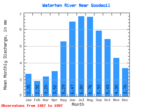
| Statistic | Jan | Feb | Mar | Apr | May | Jun | Jul | Aug | Sep | Oct | Nov | Dec | Annual |
|---|---|---|---|---|---|---|---|---|---|---|---|---|---|
| Mean | 3.30 | 2.90 | 3.15 | 3.46 | 5.21 | 6.37 | 6.70 | 6.65 | 5.84 | 5.35 | 4.24 | 3.64 | 56.38 |
| Standard Deviation | 2.55 | 2.19 | 2.25 | 2.28 | 4.58 | 6.05 | 5.38 | 4.83 | 4.09 | 3.75 | 3.10 | 2.75 | 38.42 |
| Min | 0.00 | 0.00 | 0.00 | 0.14 | 0.23 | 0.02 | 0.02 | 0.02 | 0.01 | 0.01 | 0.01 | 0.00 | 0.79 |
| Max | 10.04 | 8.77 | 9.11 | 9.92 | 25.02 | 30.80 | 26.88 | 20.67 | 15.56 | 13.32 | 10.92 | 10.39 | 189.56 |
| Coefficient of Variation | 0.77 | 0.76 | 0.71 | 0.66 | 0.88 | 0.95 | 0.80 | 0.73 | 0.70 | 0.70 | 0.73 | 0.75 | 0.68 |
 Return to R-Arctic Net Home Page