|
|
|||||||||||||||||
| Point ID: 5575 | Downloads | Plots | Site Data | Code: 06AF005 |
|
|
|||||||||||||||||
| Download | |
|---|---|
| Site Descriptor Information | Site Time Series Data |
| Link to all available data | |
| View: | Time Series | All |
| Units: | mm |
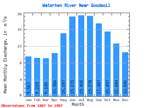
| Statistic | Jan | Feb | Mar | Apr | May | Jun | Jul | Aug | Sep | Oct | Nov | Dec | Annual |
|---|---|---|---|---|---|---|---|---|---|---|---|---|---|
| Mean | 9.57 | 9.22 | 9.13 | 10.37 | 15.10 | 19.07 | 19.41 | 19.28 | 17.49 | 15.50 | 12.68 | 10.54 | 13.86 |
| Standard Deviation | 7.40 | 6.98 | 6.52 | 6.84 | 13.28 | 18.13 | 15.59 | 14.00 | 12.24 | 10.85 | 9.27 | 7.95 | 9.45 |
| Min | 0.00 | 0.00 | 0.01 | 0.42 | 0.66 | 0.05 | 0.04 | 0.05 | 0.04 | 0.02 | 0.01 | 0.01 | 0.20 |
| Max | 29.10 | 27.90 | 26.40 | 29.70 | 72.50 | 92.20 | 77.90 | 59.90 | 46.60 | 38.60 | 32.70 | 30.10 | 46.61 |
| Coefficient of Variation | 0.77 | 0.76 | 0.71 | 0.66 | 0.88 | 0.95 | 0.80 | 0.73 | 0.70 | 0.70 | 0.73 | 0.75 | 0.68 |
 Return to R-Arctic Net Home Page