|
|
|||||||||||||||||
| Point ID: 5525 | Downloads | Plots | Site Data | Code: 05NB008 |
|
|
|||||||||||||||||
| Download | |
|---|---|
| Site Descriptor Information | Site Time Series Data |
| Link to all available data | |
| View: | Time Series | All |
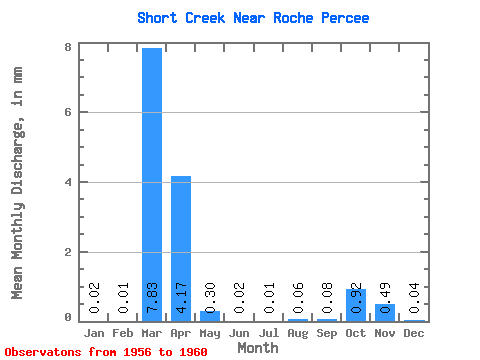
| Units: | m3/s |
| Statistic | Jan | Feb | Mar | Apr | May | Jun | Jul | Aug | Sep | Oct | Nov | Dec | Annual |
|---|---|---|---|---|---|---|---|---|---|---|---|---|---|
| Mean | 0.01 | 0.00 | 2.16 | 1.15 | 0.08 | 0.01 | 0.00 | 0.01 | 0.02 | 0.26 | 0.14 | 0.01 | |
| Standard Deviation | 2.08 | 1.63 | 0.15 | 0.01 | 0.00 | 0.03 | 0.04 | 0.51 | |||||
| Min | 0.01 | 0.00 | 0.61 | 0.19 | 0.00 | 0.00 | 0.00 | 0.00 | 0.00 | 0.00 | 0.14 | 0.01 | |
| Max | 0.01 | 0.00 | 5.18 | 3.58 | 0.31 | 0.01 | 0.00 | 0.06 | 0.09 | 1.02 | 0.14 | 0.01 | |
| Coefficient of Variation | 0.96 | 1.42 | 1.82 | 1.47 | 2.00 | 2.00 | 2.00 | 2.00 |
 Return to R-Arctic Net Home Page