|
|
| Point ID: 5525 | Downloads | Plots | Site Data | Code: 05NB008 |
|
| Download | |
|---|---|
| Site Descriptor Information | Site Time Series Data |
| Link to all available data | |
|
|
|
| View: | Statistics | All |
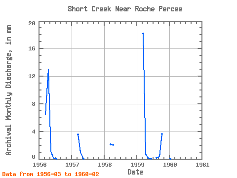
| Units: | m3/s |
| Year | Jan | Feb | Mar | Apr | May | Jun | Jul | Aug | Sep | Oct | Nov | Dec | Annual | 1956 | 1.82 | 3.58 | 0.31 | 0.01 | 0.00 | 0.00 | 0.00 | 0.00 | 1957 | 1.01 | 0.27 | 0.01 | 0.00 | 0.00 | 0.00 | 0.00 | 0.00 | 1958 | 0.61 | 0.55 | 0.00 | 0.00 | 0.00 | 0.00 | 0.00 | 0.00 | 1959 | 5.18 | 0.19 | 0.01 | 0.00 | 0.00 | 0.06 | 0.09 | 1.02 | 0.14 | 0.01 | 1960 | 0.01 | 0.00 |
|---|
 Return to R-Arctic Net Home Page