|
|
|||||||||||||||||
| Point ID: 5192 | Downloads | Plots | Site Data | Code: 05EF001 |
|
|
|||||||||||||||||
| Download | |
|---|---|
| Site Descriptor Information | Site Time Series Data |
| Link to all available data | |
| View: | Time Series | All |
| Units: | m3/s |
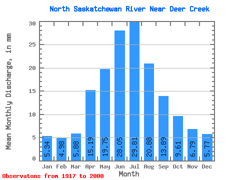
| Statistic | Jan | Feb | Mar | Apr | May | Jun | Jul | Aug | Sep | Oct | Nov | Dec | Annual |
|---|---|---|---|---|---|---|---|---|---|---|---|---|---|
| Mean | 3.99 | 3.76 | 4.40 | 11.36 | 14.77 | 20.98 | 22.29 | 15.61 | 10.38 | 7.18 | 5.07 | 4.31 | 121.49 |
| Standard Deviation | 1.68 | 1.69 | 2.39 | 4.62 | 8.90 | 10.06 | 8.66 | 6.53 | 4.50 | 2.06 | 1.74 | 1.97 | 25.95 |
| Min | 1.09 | 1.01 | 1.28 | 3.00 | 6.42 | 8.99 | 7.74 | 6.42 | 5.72 | 3.74 | 1.80 | 0.93 | 83.06 |
| Max | 6.89 | 6.20 | 9.47 | 28.42 | 62.85 | 50.39 | 38.83 | 38.55 | 37.09 | 13.79 | 8.44 | 8.54 | 208.90 |
| Coefficient of Variation | 0.42 | 0.45 | 0.54 | 0.41 | 0.60 | 0.48 | 0.39 | 0.42 | 0.43 | 0.29 | 0.34 | 0.46 | 0.21 |
 Return to R-Arctic Net Home Page