|
|
|||||||||||||||||
| Point ID: 5192 | Downloads | Plots | Site Data | Code: 05EF001 |
|
|
|||||||||||||||||
| Download | |
|---|---|
| Site Descriptor Information | Site Time Series Data |
| Link to all available data | |
| View: | Time Series | All |
| Units: | mm |
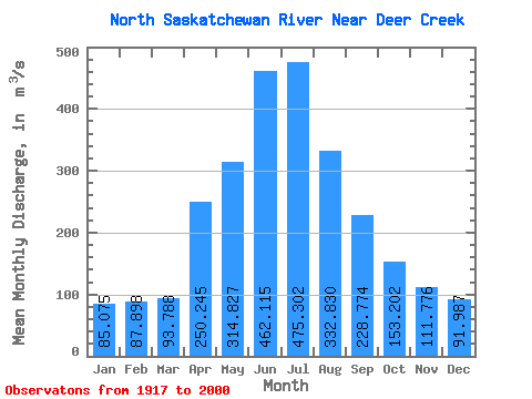
| Statistic | Jan | Feb | Mar | Apr | May | Jun | Jul | Aug | Sep | Oct | Nov | Dec | Annual |
|---|---|---|---|---|---|---|---|---|---|---|---|---|---|
| Mean | 85.08 | 87.90 | 93.79 | 250.25 | 314.83 | 462.12 | 475.30 | 332.83 | 228.77 | 153.20 | 111.78 | 91.99 | 219.81 |
| Standard Deviation | 35.81 | 39.46 | 51.01 | 101.89 | 189.85 | 221.63 | 184.58 | 139.21 | 99.03 | 44.04 | 38.28 | 42.03 | 46.94 |
| Min | 23.20 | 23.60 | 27.40 | 66.20 | 137.00 | 198.00 | 165.00 | 137.00 | 126.00 | 79.80 | 39.60 | 19.80 | 150.28 |
| Max | 147.00 | 145.00 | 202.00 | 626.00 | 1340.00 | 1110.00 | 828.00 | 822.00 | 817.00 | 294.00 | 186.00 | 182.00 | 377.96 |
| Coefficient of Variation | 0.42 | 0.45 | 0.54 | 0.41 | 0.60 | 0.48 | 0.39 | 0.42 | 0.43 | 0.29 | 0.34 | 0.46 | 0.21 |
 Return to R-Arctic Net Home Page