|
|
|||||||||||||||||
| Point ID: 5147 | Downloads | Plots | Site Data | Code: 03FB002 |
|
|
|||||||||||||||||
| Download | |
|---|---|
| Site Descriptor Information | Site Time Series Data |
| Link to all available data | |
| View: | Time Series | All |
| Units: | m3/s |
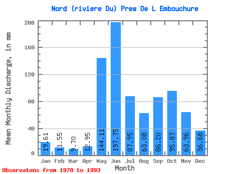
| Statistic | Jan | Feb | Mar | Apr | May | Jun | Jul | Aug | Sep | Oct | Nov | Dec | Annual |
|---|---|---|---|---|---|---|---|---|---|---|---|---|---|
| Mean | 19.60 | 11.65 | 9.70 | 12.95 | 144.09 | 197.75 | 87.94 | 63.07 | 86.20 | 95.85 | 63.96 | 36.67 | 820.13 |
| Standard Deviation | 4.90 | 3.48 | 3.42 | 9.33 | 54.25 | 81.50 | 33.10 | 37.02 | 34.58 | 21.10 | 14.07 | 12.63 | 131.89 |
| Min | 12.50 | 6.75 | 4.96 | 3.75 | 16.20 | 80.33 | 48.05 | 23.55 | 35.48 | 39.70 | 43.75 | 23.93 | 531.20 |
| Max | 28.11 | 20.25 | 18.46 | 34.56 | 203.22 | 352.95 | 157.83 | 180.43 | 134.56 | 130.48 | 90.44 | 73.12 | 1009.08 |
| Coefficient of Variation | 0.25 | 0.30 | 0.35 | 0.72 | 0.38 | 0.41 | 0.38 | 0.59 | 0.40 | 0.22 | 0.22 | 0.34 | 0.16 |
 Return to R-Arctic Net Home Page