|
|
|||||||||||||||||
| Point ID: 5147 | Downloads | Plots | Site Data | Code: 03FB002 |
|
|
|||||||||||||||||
| Download | |
|---|---|
| Site Descriptor Information | Site Time Series Data |
| Link to all available data | |

|
|
| View: | Statistics | Time Series |
| Units: | m3/s |
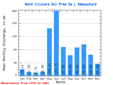
| Statistic | Jan | Feb | Mar | Apr | May | Jun | Jul | Aug | Sep | Oct | Nov | Dec | Annual |
|---|---|---|---|---|---|---|---|---|---|---|---|---|---|
| Mean | 19.60 | 11.65 | 9.70 | 12.95 | 144.09 | 197.75 | 87.94 | 63.07 | 86.20 | 95.85 | 63.96 | 36.67 | 820.13 |
| Standard Deviation | 4.90 | 3.48 | 3.42 | 9.33 | 54.25 | 81.50 | 33.10 | 37.02 | 34.58 | 21.10 | 14.07 | 12.63 | 131.89 |
| Min | 12.50 | 6.75 | 4.96 | 3.75 | 16.20 | 80.33 | 48.05 | 23.55 | 35.48 | 39.70 | 43.75 | 23.93 | 531.20 |
| Max | 28.11 | 20.25 | 18.46 | 34.56 | 203.22 | 352.95 | 157.83 | 180.43 | 134.56 | 130.48 | 90.44 | 73.12 | 1009.08 |
| Coefficient of Variation | 0.25 | 0.30 | 0.35 | 0.72 | 0.38 | 0.41 | 0.38 | 0.59 | 0.40 | 0.22 | 0.22 | 0.34 | 0.16 |
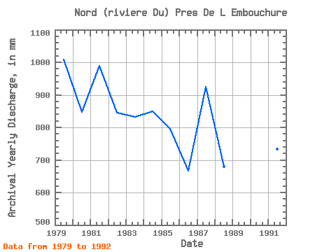
| Year | Jan | Feb | Mar | Apr | May | Jun | Jul | Aug | Sep | Oct | Nov | Dec | Annual | 1978 | 72.93 | 180.43 | 102.58 | 95.72 | 60.85 | 34.76 | 1979 | 19.56 | 11.20 | 8.60 | 6.78 | 168.09 | 284.94 | 101.99 | 77.49 | 110.67 | 101.23 | 77.39 | 42.54 | 1009.08 | 1980 | 22.79 | 12.56 | 9.53 | 9.63 | 203.22 | 139.16 | 95.15 | 44.44 | 102.21 | 100.85 | 67.28 | 44.06 | 847.23 | 1981 | 28.11 | 20.25 | 18.46 | 13.03 | 86.61 | 352.95 | 157.83 | 49.95 | 38.24 | 103.32 | 90.44 | 30.01 | 989.53 | 1982 | 16.85 | 11.97 | 11.15 | 10.33 | 171.70 | 174.82 | 114.34 | 65.53 | 46.88 | 79.39 | 72.98 | 73.12 | 844.92 | 1983 | 24.50 | 10.02 | 7.33 | 12.15 | 188.60 | 175.93 | 92.50 | 41.02 | 74.45 | 118.90 | 61.03 | 29.06 | 832.01 | 1984 | 18.61 | 13.24 | 12.95 | 34.56 | 176.63 | 80.33 | 58.88 | 60.40 | 130.34 | 130.48 | 85.48 | 51.28 | 849.94 | 1985 | 27.16 | 15.14 | 12.08 | 11.82 | 94.39 | 220.60 | 54.32 | 39.31 | 107.36 | 106.55 | 70.77 | 36.47 | 796.54 | 1986 | 20.32 | 12.27 | 10.29 | 12.59 | 164.67 | 108.83 | 49.38 | 45.20 | 76.29 | 99.90 | 44.12 | 26.02 | 666.94 | 1987 | 16.05 | 9.95 | 8.34 | 24.82 | 181.76 | 204.05 | 85.47 | 94.20 | 112.50 | 85.47 | 66.55 | 38.94 | 925.70 | 1988 | 23.36 | 14.80 | 12.38 | 29.78 | 199.43 | 129.97 | 60.40 | 52.42 | 46.51 | 39.70 | 46.88 | 27.73 | 680.76 | 1989 | 13.39 | 7.56 | 6.33 | 5.77 | 120.80 | 128.50 | 48.05 | 23.55 | 35.48 | 75.97 | 43.75 | 23.93 | 531.20 | 1990 | 12.50 | 6.75 | 4.96 | 3.75 | 153.27 | 205.89 | 92.31 | 58.50 | 118.75 | 98.57 | 52.58 | 32.67 | 838.49 | 1991 | 19.94 | 11.65 | 8.91 | 6.86 | 91.93 | 233.46 | 89.08 | 40.08 | 56.25 | 89.08 | 60.30 | 26.40 | 733.51 | 1992 | 12.91 | 6.97 | 5.60 | 4.98 | 16.20 | 329.06 | 146.44 | 73.50 | 134.56 | 112.63 | 59.01 | 33.05 | 936.02 | 1993 | 18.00 | 10.44 | 8.53 | 7.32 |
|---|
 Return to R-Arctic Net Home Page