|
|
|||||||||||||||||
| Point ID: 5134 | Downloads | Plots | Site Data | Code: 03EA002 |
|
|
|||||||||||||||||
| Download | |
|---|---|
| Site Descriptor Information | Site Time Series Data |
| Link to all available data | |
| View: | Time Series | All |
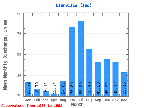
| Units: | m3/s |
| Statistic | Jan | Feb | Mar | Apr | May | Jun | Jul | Aug | Sep | Oct | Nov | Dec | Annual |
|---|---|---|---|---|---|---|---|---|---|---|---|---|---|
| Mean | 23.72 | 16.85 | 15.11 | 12.74 | 24.80 | 76.80 | 82.28 | 55.47 | 43.20 | 45.91 | 43.17 | 33.16 | 443.72 |
| Standard Deviation | 1.77 | 0.73 | 1.18 | 0.99 | 14.73 | 8.72 | 26.21 | 11.79 | 8.53 | 6.34 | 6.95 | 2.95 | 1.77 |
| Min | 21.30 | 16.03 | 14.15 | 11.96 | 13.52 | 66.90 | 55.09 | 46.80 | 32.95 | 39.28 | 36.78 | 28.95 | 442.47 |
| Max | 25.38 | 17.78 | 16.71 | 14.19 | 46.29 | 84.67 | 117.70 | 72.31 | 53.81 | 51.52 | 50.73 | 35.83 | 444.97 |
| Coefficient of Variation | 0.07 | 0.04 | 0.08 | 0.08 | 0.59 | 0.11 | 0.32 | 0.21 | 0.20 | 0.14 | 0.16 | 0.09 | 0.00 |
 Return to R-Arctic Net Home Page