|
|
| Point ID: 5134 | Downloads | Plots | Site Data | Code: 03EA002 |
|
| Download | |
|---|---|
| Site Descriptor Information | Site Time Series Data |
| Link to all available data | |
|
|
|
| View: | Statistics | All |
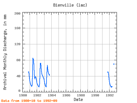
| Units: | m3/s |
| Year | Jan | Feb | Mar | Apr | May | Jun | Jul | Aug | Sep | Oct | Nov | Dec | Annual | 1980 | 51.14 | 50.73 | 35.83 | 1981 | 25.38 | 17.78 | 16.71 | 14.19 | 17.47 | 84.67 | 82.25 | 46.80 | 32.95 | 39.28 | 36.78 | 28.95 | 442.47 | 1982 | 21.30 | 16.96 | 15.30 | 12.47 | 21.93 | 72.08 | 74.09 | 54.96 | 43.57 | 41.70 | 37.77 | 33.79 | 444.97 | 1983 | 24.61 | 16.61 | 14.28 | 12.33 | 46.29 | 66.90 | 55.09 | 47.82 | 42.46 | 1991 | 51.52 | 47.40 | 34.05 | 1992 | 23.59 | 16.03 | 14.15 | 11.96 | 13.52 | 83.56 | 117.70 | 72.31 | 53.81 |
|---|
 Return to R-Arctic Net Home Page