|
|
|||||||||||||||||
| Point ID: 5127 | Downloads | Plots | Site Data | Code: 03DE002 |
|
|
|||||||||||||||||
| Download | |
|---|---|
| Site Descriptor Information | Site Time Series Data |
| Link to all available data | |
| View: | Time Series | All |
| Units: | m3/s |
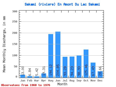
| Statistic | Jan | Feb | Mar | Apr | May | Jun | Jul | Aug | Sep | Oct | Nov | Dec | Annual |
|---|---|---|---|---|---|---|---|---|---|---|---|---|---|
| Mean | 13.00 | 6.90 | 5.42 | 19.31 | 194.09 | 204.85 | 93.27 | 94.21 | 98.93 | 125.44 | 67.49 | 28.65 | 978.92 |
| Standard Deviation | 6.08 | 2.68 | 1.27 | 27.62 | 92.59 | 80.68 | 57.49 | 63.73 | 43.66 | 70.83 | 32.65 | 11.80 | 226.55 |
| Min | 7.27 | 4.36 | 4.16 | 3.46 | 84.95 | 61.04 | 37.87 | 22.17 | 27.04 | 29.23 | 20.21 | 16.41 | 518.62 |
| Max | 28.51 | 13.77 | 7.83 | 103.12 | 403.14 | 338.63 | 204.45 | 211.65 | 168.62 | 246.20 | 122.08 | 58.60 | 1245.57 |
| Coefficient of Variation | 0.47 | 0.39 | 0.23 | 1.43 | 0.48 | 0.39 | 0.62 | 0.68 | 0.44 | 0.56 | 0.48 | 0.41 | 0.23 |
 Return to R-Arctic Net Home Page