|
|
|||||||||||||||||
| Point ID: 5127 | Downloads | Plots | Site Data | Code: 03DE002 |
|
|
|||||||||||||||||
| Download | |
|---|---|
| Site Descriptor Information | Site Time Series Data |
| Link to all available data | |
| View: | Time Series | All |
| Units: | mm |
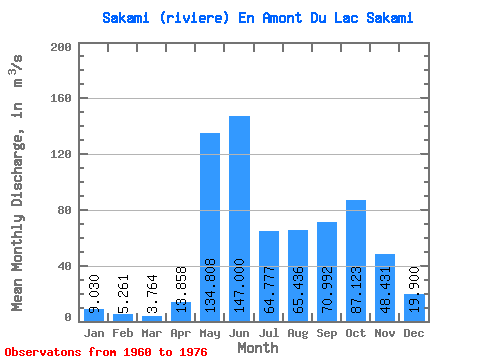
| Statistic | Jan | Feb | Mar | Apr | May | Jun | Jul | Aug | Sep | Oct | Nov | Dec | Annual |
|---|---|---|---|---|---|---|---|---|---|---|---|---|---|
| Mean | 9.03 | 5.26 | 3.76 | 13.86 | 134.81 | 147.00 | 64.78 | 65.44 | 70.99 | 87.12 | 48.43 | 19.90 | 57.69 |
| Standard Deviation | 4.22 | 2.04 | 0.88 | 19.82 | 64.31 | 57.90 | 39.93 | 44.26 | 31.33 | 49.19 | 23.43 | 8.20 | 13.35 |
| Min | 5.05 | 3.32 | 2.89 | 2.48 | 59.00 | 43.80 | 26.30 | 15.40 | 19.40 | 20.30 | 14.50 | 11.40 | 30.57 |
| Max | 19.80 | 10.50 | 5.44 | 74.00 | 280.00 | 243.00 | 142.00 | 147.00 | 121.00 | 171.00 | 87.60 | 40.70 | 73.41 |
| Coefficient of Variation | 0.47 | 0.39 | 0.23 | 1.43 | 0.48 | 0.39 | 0.62 | 0.68 | 0.44 | 0.56 | 0.48 | 0.41 | 0.23 |
 Return to R-Arctic Net Home Page