|
|
|||||||||||||||||
| Point ID: 5104 | Downloads | Plots | Site Data | Code: 03CB003 |
|
|
|||||||||||||||||
| Download | |
|---|---|
| Site Descriptor Information | Site Time Series Data |
| Link to all available data | |
| View: | Time Series | All |
| Units: | m3/s |
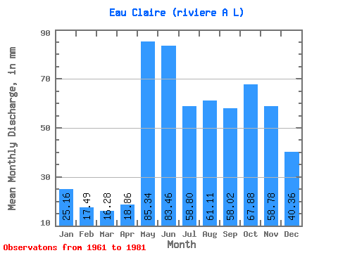
| Statistic | Jan | Feb | Mar | Apr | May | Jun | Jul | Aug | Sep | Oct | Nov | Dec | Annual |
|---|---|---|---|---|---|---|---|---|---|---|---|---|---|
| Mean | 25.16 | 17.64 | 16.28 | 18.86 | 85.33 | 83.46 | 58.79 | 61.10 | 58.02 | 67.87 | 58.78 | 40.35 | 602.41 |
| Standard Deviation | 5.56 | 3.83 | 3.12 | 10.44 | 29.73 | 27.68 | 15.42 | 33.09 | 32.49 | 30.75 | 20.23 | 13.09 | 166.06 |
| Min | 16.33 | 12.15 | 11.79 | 10.73 | 40.81 | 37.56 | 39.38 | 26.49 | 21.07 | 21.34 | 21.76 | 20.19 | 342.41 |
| Max | 36.09 | 26.75 | 22.48 | 56.41 | 157.53 | 152.47 | 100.96 | 148.94 | 129.32 | 126.60 | 98.14 | 70.31 | 980.13 |
| Coefficient of Variation | 0.22 | 0.22 | 0.19 | 0.55 | 0.35 | 0.33 | 0.26 | 0.54 | 0.56 | 0.45 | 0.34 | 0.32 | 0.28 |
 Return to R-Arctic Net Home Page