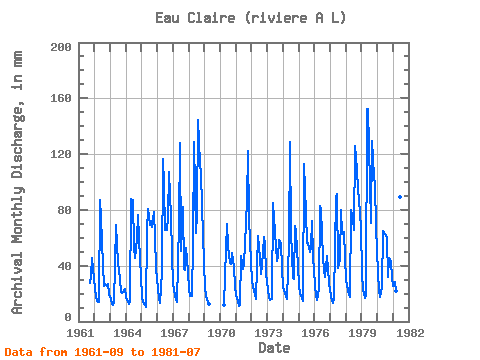
| Point ID: 5104 | Downloads | Plots | Site Data | Code: 03CB003 |
| Download | |
|---|---|
| Site Descriptor Information | Site Time Series Data |
| Link to all available data | |

|

|
| View: | Statistics | Time Series |
| Units: | m3/s |
| Statistic | Jan | Feb | Mar | Apr | May | Jun | Jul | Aug | Sep | Oct | Nov | Dec | Annual |
|---|---|---|---|---|---|---|---|---|---|---|---|---|---|
| Mean | 25.16 | 17.64 | 16.28 | 18.86 | 85.33 | 83.46 | 58.79 | 61.10 | 58.02 | 67.87 | 58.78 | 40.35 | 602.41 |
| Standard Deviation | 5.56 | 3.83 | 3.12 | 10.44 | 29.73 | 27.68 | 15.42 | 33.09 | 32.49 | 30.75 | 20.23 | 13.09 | 166.06 |
| Min | 16.33 | 12.15 | 11.79 | 10.73 | 40.81 | 37.56 | 39.38 | 26.49 | 21.07 | 21.34 | 21.76 | 20.19 | 342.41 |
| Max | 36.09 | 26.75 | 22.48 | 56.41 | 157.53 | 152.47 | 100.96 | 148.94 | 129.32 | 126.60 | 98.14 | 70.31 | 980.13 |
| Coefficient of Variation | 0.22 | 0.22 | 0.19 | 0.55 | 0.35 | 0.33 | 0.26 | 0.54 | 0.56 | 0.45 | 0.34 | 0.32 | 0.28 |
| Year | Jan | Feb | Mar | Apr | May | Jun | Jul | Aug | Sep | Oct | Nov | Dec | Annual | 1961 | 27.31 | 33.37 | 45.33 | 38.81 | 1962 | 24.77 | 16.44 | 15.32 | 13.70 | 89.94 | 74.57 | 40.96 | 26.49 | 26.75 | 26.49 | 27.17 | 20.19 | 401.79 | 1963 | 16.33 | 12.15 | 11.89 | 13.51 | 71.32 | 55.30 | 43.53 | 31.36 | 21.07 | 21.34 | 21.76 | 24.20 | 342.41 | 1964 | 18.33 | 13.18 | 12.69 | 14.14 | 90.36 | 87.05 | 54.71 | 47.12 | 59.33 | 78.77 | 59.46 | 33.08 | 566.45 | 1965 | 18.04 | 12.92 | 12.10 | 10.73 | 66.73 | 80.53 | 71.75 | 74.47 | 67.64 | 80.77 | 60.30 | 39.81 | 593.49 | 1966 | 24.34 | 15.01 | 13.99 | 35.34 | 120.44 | 98.00 | 67.45 | 68.02 | 73.88 | 110.56 | 74.85 | 49.41 | 748.45 | 1967 | 28.07 | 17.75 | 15.75 | 14.14 | 72.61 | 128.07 | 52.56 | 85.07 | 37.42 | 38.24 | 52.39 | 36.80 | 577.76 | 1968 | 23.06 | 17.09 | 19.05 | 56.41 | 133.18 | 63.76 | 79.91 | 148.94 | 112.83 | 109.12 | 82.75 | 43.39 | 885.48 | 1969 | 24.77 | 17.48 | 16.33 | 12.90 | 1970 | 11.85 | 53.85 | 70.14 | 55.99 | 43.53 | 41.17 | 50.70 | 39.23 | 26.49 | 1971 | 19.62 | 14.09 | 11.79 | 12.00 | 48.40 | 37.56 | 42.82 | 57.43 | 86.49 | 126.60 | 74.02 | 43.25 | 571.98 | 1972 | 30.93 | 23.09 | 20.62 | 16.36 | 40.81 | 61.40 | 47.12 | 34.94 | 39.50 | 62.58 | 55.86 | 35.09 | 467.77 | 1973 | 23.63 | 16.83 | 16.04 | 16.22 | 87.64 | 74.30 | 66.31 | 44.82 | 46.16 | 60.58 | 56.41 | 39.38 | 546.39 | 1974 | 25.35 | 19.31 | 18.62 | 16.36 | 58.72 | 128.63 | 66.16 | 31.94 | 30.63 | 70.60 | 64.18 | 40.96 | 570.87 | 1975 | 26.35 | 18.53 | 17.18 | 14.83 | 116.72 | 77.76 | 58.29 | 58.14 | 49.76 | 55.28 | 71.80 | 48.83 | 611.23 | 1976 | 27.21 | 17.35 | 16.04 | 23.15 | 85.64 | 79.70 | 47.98 | 37.52 | 32.16 | 48.40 | 37.70 | 28.64 | 480.15 | 1977 | 18.90 | 13.70 | 13.36 | 16.77 | 92.37 | 91.07 | 39.38 | 45.25 | 79.70 | 64.44 | 64.04 | 46.83 | 584.83 | 1978 | 30.50 | 21.27 | 19.76 | 17.74 | 82.78 | 73.05 | 67.74 | 129.89 | 109.36 | 96.52 | 88.02 | 68.88 | 802.50 | 1979 | 35.52 | 21.01 | 17.76 | 18.43 | 157.53 | 152.47 | 100.96 | 73.18 | 129.32 | 108.12 | 98.14 | 70.31 | 980.13 | 1980 | 36.09 | 21.27 | 18.47 | 24.39 | 67.02 | 63.21 | 64.30 | 61.72 | 31.88 | 46.97 | 43.38 | 32.37 | 509.26 | 1981 | 26.21 | 26.75 | 22.48 | 18.30 | 85.21 | 89.13 | 49.12 |
|---|
 Return to R-Arctic Net Home Page