|
|
|||||||||||||||||
| Point ID: 5092 | Downloads | Plots | Site Data | Code: 03BB001 |
|
|
|||||||||||||||||
| Download | |
|---|---|
| Site Descriptor Information | Site Time Series Data |
| Link to all available data | |
| View: | Time Series | All |
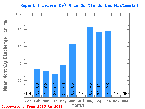
| Units: | m3/s |
| Statistic | Jan | Feb | Mar | Apr | May | Jun | Jul | Aug | Sep | Oct | Nov | Dec | Annual |
|---|---|---|---|---|---|---|---|---|---|---|---|---|---|
| Mean | 33.97 | 31.81 | 28.07 | 38.02 | 63.65 | 83.45 | 77.12 | 77.97 | |||||
| Standard Deviation | 6.78 | 1.52 | |||||||||||
| Min | 33.97 | 31.81 | 28.07 | 38.02 | 58.86 | 83.45 | 76.04 | 77.97 | |||||
| Max | 33.97 | 31.81 | 28.07 | 38.02 | 68.45 | 83.45 | 78.19 | 77.97 | |||||
| Coefficient of Variation | 0.11 | 0.02 |
 Return to R-Arctic Net Home Page